Airbus has launched a unique new aircraft that has set a new endurance record — and whose capabilities may create a whole new category of Earth observation.
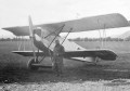
The Zephyr S is a new class of aircraft that Airbus calls an HAPS — high altitude pseudo satellite.
It’s a solar-electric powered, stratospheric UAV, with a wingspan of 25 metres and a gross weight of 75 kilograms — one of which has recently surpassed the world aircraft endurance record of 14 days, 22 minutes and 8 seconds without refueling.
Running on solar power, above commercial air traffic and atmospheric weather systems, Airbus envisions the Zephyr to provide ‘satellite like’ services:
‘Ideally suited for “local persistence” (ISR/Intelligence, Surveillance & Reconnaissance), the Zephyr has the ability to stay focused on a specific area of interest (which can be hundreds of miles wide) while providing it with satellite-like communications and Earth observation services (with greater imagery granularity) over long periods of time without interruption.’
The Zephyr S is the production model, following prior R&D focused prototypes of the aircraft.
Its maiden voyage breaking the record after its July 11 take-off, aimed to show off its capabilities ahead of the formal opening of its production facilities on July 16 — a bold move demonstrating Airbus’ commitment to this class-defining vehicle.
From September 2018, Airbus will be flying Zephyr S from their new operating site at Wyndham airfield in Western Australia.
Wyndham has been chosen as the first launch and recovery site for the Zephyr UAV due mainly to its largely unrestricted airspace and reliable weather.
Stay up to date by getting stories like this delivered to your mailbox.
Sign up to receive our free weekly Spatial Source newsletter.