CSDILA researchers have developed an AI process that puts real-world geospatial assignments to the test.
Dr Yiqun Chen, Centre for Spatial Data Infrastructures and Land Administration, The University of Melbourne
Suppose an asset manager at a process plant asks a simple question: Which of our pumps sit in the part of the yard that floods first in a 40-millimetre-per-hour storm, and would raising the bund (containment wall) by half a metre change that?
Nothing in that question is hard to state, but everything in it is slow to answer:
- Somebody has to establish what is actually in the yard today, not what the drawings say.
- Somebody has to turn the question into a spatial query across several datasets.
- And somebody has to run a hydraulic model, then run it again with the bund raised.
Three bottlenecks, three specialists, several weeks’ work.
At the Centre for Spatial Data Infrastructures and Land Administration (CSDILA) we have been working on each bottleneck, and in each case the useful tool turns out to be a different kind of AI — vision models that find and label the assets in a scan, language-model agents that turn a question into a validated analysis, and learned surrogates that reproduce a physics simulation in seconds.
We cannot yet chain them end to end, but each piece works, and this article describes them in the order that the question needs.
What is in the yard: Gaussian splatting inside a working plant
The answer to the process plant question starts with a current, labelled asset of the site. Process plants are hard to capture — dense, heavily occluded, and changing faster than the drawings do. Laser scanning handles the geometry, but a point cloud still needs someone to say what each object is, and that is where the time goes.
Along with an industry partner, we at CSDILA are trialling an alternative.
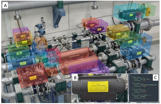
A technician walks the site with a handheld scanner, and the scene is reconstructed as a 3D Gaussian splat — millions of tiny translucent blobs that render photo-realistically from any angle.
On the way ’round, the technician taps the app near each asset of interest and takes a reference photo. That is nearly all the human input.
The tap records where the scanner was, not where the object is, so the pipeline casts a ray from that position and treats the first surface it hits as the object centre. Twelve virtual cameras render it from all sides. A vision model marks the object in each view, and a segmentation model refines the box into an exact outline.
Each outline is projected back into the scene and votes for the splats inside it. Splats that two or three views agree on are kept. Stray points are removed, and an orientated bounding box is fitted around the largest cluster. The reference photo is read for label text and written out as a structured record.
The result is a scan we can query: each asset has a position, footprint, orientation and identity. Current capture provides enough details for our optimised text detection algorithm to extract key asset information such as model name and serial number which can then be linked back to the plant’s existing Asset Management System (AMS) for integration. (See Figure 1 at the top of the page.)
Asking the question: Agentic spatial analysis
The next part of the answer to the asset manager’s question is a spatial join between an asset inventory, a flood layer and a depth threshold. Most of the people who need this kind of answer cannot write a PostGIS query, and the people who can have a backlog.
Large language models look like the obvious solution, but on their own they are unreliable — ask one a spatial question and we get SQL that reads well and does not run.
On our hardest test queries, which involve several tables and 3D geometry, a single-agent baseline produced spatially valid logic only 15% of the time and never executed successfully.
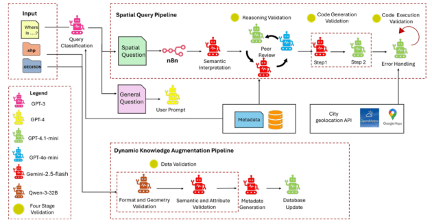
Our Spatial Query and Analysis (SQA) framework, published open access in the Journal of Geovisualization and Spatial Analysis earlier this year, builds validation into the architecture.
A plain-English question passes through several agents — one interprets intent, one designs the spatial operation, one reviews that design independently, and one checks that the query runs. A retrieval step gives the agents the real database schema. When a query fails, a two-pass recovery loop diagnoses and repairs it.
On the same hard queries, tested on a university campus dataset, the full framework reached 100% spatial validity and 90% execution success.
The recovery loop matters: mismatched coordinate reference systems turned up in 5% of queries and were only caught on the second pass.
Testing the change: AI surrogates
The second part of the plant manager’s question — would raising the bund help? — involves a simulation.
Physics-based flood and microclimate models are well validated but slow. Surrogate modelling keeps the physics and removes the wait — run the rigorous model many times offline, then train a neural network to reproduce its output.
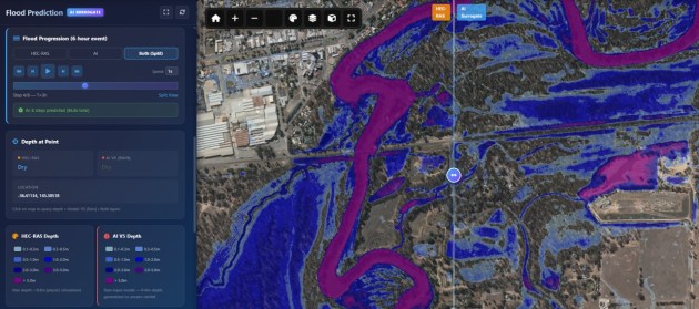
Our flood surrogate is trained on HEC-RAS hydrodynamic runs spanning rainfall from zero to 50 millimetres per hour and reproduces 98.8% of peak flood depth at two-metre resolution. Terrain is one of its inputs, so a raised bund is a changed input rather than a fresh model run.
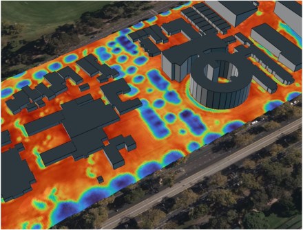
A surrogate can only be trusted for changes it has seen in training, though, which is why terrain edits are on the flood model’s test list and why the heat model shown in Figure 3 was trained with synthetic interventions. It also runs on live Bureau of Meteorology rainfall and forecasts, reporting the buildings and roads inside the predicted extent.
Urban heat uses the same recipe. In a project with the City of Melbourne, the physics model is UMEP/SOLWEIG computing mean radiant temperature. We tile the municipality into 512-metre patches at one-metre resolution, use building height, vegetation and albedo as inputs, and add two synthetic variants for every real patch (extra canopy, cool roofs) so the network learns cause and effect.
Drop a tree on a footpath in the browser and the cooler patch appears beneath it in less than a second.
Both currently are working pilots rather than operational systems. A surrogate also inherits every assumption of the model that trained it. If the physics is wrong, the network is wrong faster.
Closing the loop
Back to the original question. Each step of the asset manager’s answer now exists — a scan that knows what a pump is, a query engine that can be asked in plain English, and a flood model that answers a what-if in seconds.
What does not yet exist is the plumbing between them — the scan’s inventory feeding the query, and the query result feeding the surrogate. That is the next job.
None of this replaces analysts. It simply shortens the distance between a question and a decision.
Dr Yiqun Chen is a Senior Research Fellow and Tech Lead at the Centre for Spatial Data Infrastructures and Land Administration, The University of Melbourne. His work applies AI to spatial data infrastructure, digital twin ecosystem and 3D reality capture.
CSDILA has been part of the University of Melbourne since 2001. The work described above has been carried by the centre’s technical team of Mazdak Ghasemi Tootkaboni, Zezheng Zhang, Yuke Xie and Tonglong Song, and by PhD researchers Ensiyeh Javaherian Pour and Masoud Kamali, under the leadership of Associate Professor Alice Kesminas and Professor Abbas Rajabifard.
The research is funded by RIIS, a research and innovation hub supported by industry and the Australian Research Council, and by the City of Melbourne.
Further information:
- Javaherian Pour, E., Chen, Y., Kesminas, A., Rajabifard, A., & Ghasemi Tootkaboni, M. (2026). An Automated Framework for Natural Language-Based Spatial Query Using Large Language Models. Journal of Geovisualization and Spatial Analysis, 10:19. https://doi.org/10.1007/s41651-026-00260-9
- Centre for Spatial Data Infrastructures and Land Administration (CSDILA)
- UMEP, the physics model behind the heat surrogate.
- HEC-RAS, the physics model behind the flood surrogate.