
The Association of Public Authority Surveyors, NSW (APAS) annual conference for 2023 will be held at Opal Cove Resort in Coffs Harbour, from 20 to 22 March 2023.
The theme for the event will the ‘Pirates of the Cadastre’. The program is being developed, with a call for abstracts currently in place (as of June 2022).
Important dates and deadlines to note, are:
- Abstract submission deadline: Friday, 23 September 2022
- Draft paper deadline: Friday, 18 November 2022
- Final paper deadline: Friday, 20 January 2023
Each year, the Locate conference attracts hundreds of national and international delegates from within and outside the spatial and surveying industry.
As Australia’s premier spatial and surveying conference, Locate provides guests with a unique opportunity to learn about the latest trends and applications in geospatial technologies.
Are you passionate about our industry and want to get involved? Maybe you have an idea for a local tour, or a project site visit or even have another event that can run in conjunction with Locate. This is your opportunity to help shape the 2023 event — no idea is too big or too small. Reach out to the organisers via info@locateconference.com or +61 2 4319 8519.

The Local Government Spatial Reference Group (LGSRG) will be holding a webinar on Monday, 4 September, to introduce a series of hands-on workshops it will be holding across Victoria during September 2023.
The webinar will cover the topic of Best Practice Geospatial Intelligence for Climate Impact, and will address important topics on climate impact, community safety and how geospatial intelligence can contribute to better outcomes for local governments.
The LGSRG was formed in 2003 to address the need for a sector wide group representing the strategic interests of the Victorian Local Government sector with respect to spatial information. The LGSRG has been active throughout the COVID pandemic to keep the local government geospatial community connected and engaged via the annual Spatial Capability Workshop series which have grown year on year, and is now diversifying with a quarterly Spatial Hour webinar to share stories of success within the local government geospatial sector.
Image credit: ©stock.adobe.com/au/yutthana
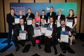
Each year representatives from the Association of Consulting Surveyors NSW and the Institution of Surveyors NSW come together to organise the NSW Excellence in Surveying and Spatial Information (EISSI) Awards.
The awards recognise the achievements of organisations and individuals from across the state who are engaged in the surveying and spatial information profession; celebrate excellence before an audience of industry peers; encourage activities that create a stronger, larger and more relevant industry; and embrace the achievements of the industry and its related industries and professions.
SmartSat partners, participants, students and staff are invited to come together to share their research outcomes and network with industry colleagues at the SmartSat CRC Conference 2023.
The SmartSat CRC is a consortium of universities and other research organisations, partnered with industry that has been funded by the Australian Government to develop know-how and technologies in advanced telecommunications and IoT connectivity, intelligent satellite systems and Earth observation next generation data services.
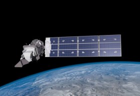
Landsat image courtesy NASA/GSFC

The International Association of the IEEE-Geoscience and Remote Sensing Society (GRSS), the IEEE-Computational Intelligence Society (CIS) and the local organising committee invite geospatial and computing professionals to attend the International Conference on Machine Intelligence for GeoAnalytics and Remote Sensing (MIGARS) to be held in Wellington, Aotearoa New Zealand in April 2024.
MIGARS aims to explore the interface of machine intelligence approaches with geosciences, spatial analytics, and remote sensing. With the tremendous developments in remote sensing technology, data acquisitions and sensing platforms, digital data have grown leaps and bounds to stream and are too big by volume, variety, and veracity. The challenge is handling, processing, and automating geo-data from various sources, such as multi-platform remote sensors and IoT devices, informing decision-making and monitoring our planet.
The conference will focus on connecting researchers from various disciplines, including computation/artificial intelligence, engineering, remote sensing, hydrology, agriculture and geosciences, and look for the potential use of intelligent computational approaches for geo-data-based applications and for serving society at large.

The 4th International Symposium on Applied Geoinformatics (ISAG2024), which will take place at the Wroclaw University of Science and Technology, Wroclaw, Poland, on 9 and 10 May 2024. ISAG2024 is jointly organised by the Department of Geomatics Engineering, Yildiz Technical University, Istanbul, Türkiye, Wroclaw University of Science and Technology, Wroclaw, Poland and Technical University of Crete, Chania, Crete, Greece.
The aim of the 4th ISAG is to bring scientists, engineers and industry researchers together to exchange and share their experiences and research results and discuss the practical challenges encountered and the solutions adopted in geoinformatics.
Topics to be covered include recent advances in AI, satellite imagery, advanced remote sensing, photogrammetry, image processing, global navigation satellite systems, height systems, terrestrial laser scanning, GIS, smart cities and land management.
The International Federation of Surveyors (FIG) Working Week 2024 will be held in Accra, Ghana, from 19 to 24 May. The event is being held in cooperation with the two national associations: the Licensed Surveyors Association of Ghana (LiSAG) and the Ghana Institution of Surveyors (GhIS).
The event will comprise the following:
- Conference: 20-22 May
- FIG General Assembly: 19 and 23 May
- Pre- and post-events: 18-19 and 23 May
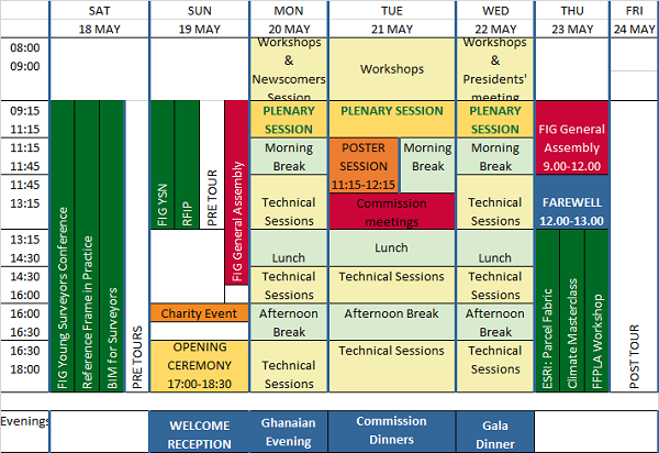
The FIG Working Week will be a week-long celebration of innovation and collaboration that unites the global community of surveying and spatial professionals, providing an opportunity to bridge the gap between science and the policymakers and stakeholders who drive real-world change.
The event will provide attendees the opportunity to:
- Immerse themselves at the forefront of geospatial technology and sustainable resource management.
- Elevate their expertise through hands-on workshops, interactive sessions, and thought-provoking discussions.
- Connect with like-minded professionals, experts and decision-makers from around the world.
The FIG Working Week 2024 is expected to attract more than 1500 attendees from around 80 countries, to participate in 70-plus presentation sessions and networking opportunities, and to experience a comprehensive trade exhibition.

The Geospatial Council of Australia’s Spatial Information Day will be an immersive journey into the dynamic world of geospatial data and technology.
Delegates will have the opportunity to engage with industry leaders, renowned experts and fellow enthusiasts, while delving into the latest advancements reshaping the understanding of space and place. On the agenda will be innovative solutions driving progress across sectors such as urban planning, environment management and disaster response.
The event will be followed in the evening by the 2024 SA Geospatial Excellence Awards Dinner, the industry’s premier platform to celebrate the achievements of top geospatial organisations and individuals in the state.
The annual conference of Survey and Spatial New Zealand (S+SNZ) will take place in August in Napier, on the east coast of New Zealand’s North Island.
Napier was the epicentre of destruction wrought by Cyclone Gabrielle in 2023, so the theme for the 2024 event is ‘Looking Ahead in the Heartland,’ which S+SNZ says, refers “not just to the optimism and resilience of provincial New Zealand, but also provides an opportunity to discuss approaches to the challenges of climate change and disaster recovery around the country”.
Super-early bird registration is now open.


