Location is a unifying theme in business. Location can be an address, a service boundary, a sales territory, or a delivery route. All these things can be visualised and interactively managed and analyzed. Spatial relationships, patterns and trends reveal invaluable business intelligence and bring easy-to-understand visualisation to business applications.

Location Intelligence Solutions can be used in sales and marketing, transportation and logistics, inventory management and procurement, customer relationship management, retailing, manufacturing, claims and risk management, health care, real estate and more.
OMNILINK are the appointed Exclusive Australasian Distributor for Visual Crossing. The Visual Crossing technology provides a spatial dimension to MicroStrategy Business Intelligence (BI) product. Visual Crossing delivers a multi-level, multi-dimensional capability that draws upon existing MicroStrategy investments in queries, drills, dashboard and data investments. Visual Crossing is developed using the same architecture and metadata structures as MicroStrategy.
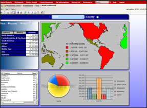
OMNILINK’s partnership with Visual Crossing compliments our data management and supply services as all uses of Location Intelligence Solutions will require “mapping data”. Client locations, sales territories, transport routes, demographic profiles, store layouts, are just a few examples of what can be presented via Visual Crossing as an interactive dashboard. Inclusion of Google and Bang maps drops for easy use by end customers is a standard feature. OMNILINK can provide Australian and New Zealand based mapping and demographic data to support your business intelligence mapping requirements.
There are 4 key product components:
- Spatial Architect – Enterprise – main software offering. – Spatial Architect including region builder and a suite of powerful analytical tools.
- Spatial Architect – Small Business – for less than 50 users. Functionality as for Enterprise
- Spatial Designer – design level licence allowing for configuration of software, analysis, region creation, geo-coding and publishing of dynamic dashboards.
- Spatial Viewer – viewer licence (read-only) working with predominantly pre-built queries, reports and dashboards.
Demonstration systems have been developed for other sectors including retail, agriculture and wealth management. The diversity of uses for mapping within the traditional business intelligence environment are enormous.