Each week, Spatial Source finds the best that the internet has to offer.

The rich promise of autonomous driving is often discussed, with benefits from cheaper car insurance, to shorter journey times being touted. The question, however, is how do we get there? How do we get to a place where these benefits aren’t just discussed, but realized? HERE proposes that the answer relies on us first “mastering the map.” [HERE Blog]

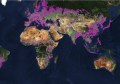
20 March marked World Happiness Day. In response, Views of the World shared this map showing the unhappiest countries depicted by relative size. Which country do you think is the most unhappy? And the happiest? Find out here… [Views of the World]

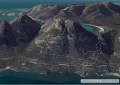
The Mirador Basin Project is using a LiDAR system capable of mapping 560,000 points per second to provide an accurate topographical map of a large pre-Columbian Maya settlement called El Mirador, located in the north of El Petén, Guatemala. The Maya settlement contains some of the largest pyramids in the world, and is rumoured to have once been the heart of the Maya civilisation. [Spar 3D]

What a waste! The University of Leeds and the International Solid Waste Association have created an interactive map which explores & visualises waste management issues across the globe. The Waste Atlas includes information about landfills, dumpsites and waste management in 164 different countries. [Maps Mania]
Many people have issues with the commonly used Mercator projection, namely that it shows the Earth with distorted areas and therefore emphasises the influence of certain nations. The Peters projection map, also referred to as the Gall-Peters projection map, is considered an equal-area representation of the globe and will now be used in classrooms in Boston for this very reason. [WBUR]