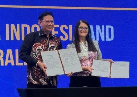
Surveyors Australia and Ikatan Surveyor Indonesia (ISI) have signed a three-year memorandum of understanding to strengthen cooperation between the two countries.
The agreement was signed at the opening of the FIT ISI & GEODETA 2026 event held in Semarang on 26 and 27 October. The conference brought together experts in surveying, geospatial technology, planning and environmental management.
Surveyors Australia’s CEO, Michelle Blicavs, said the conference highlighted the importance of reliable spatial data in sustainable development, disaster preparedness and recovery.
“Surveyors have a critical role in gathering accurate data and helping ensure it can be used to make sound decisions about land, infrastructure and communities,” she said.
“That matters when planning for growth, managing environmental risks or rebuilding after a disaster.
“The quality of the information, and how it is shared and used, can have lasting consequences.”
Initial framework and future pathways
The new agreement provides a framework for cooperation on professional standards and certification, education and training, workforce development, professional exchange, and technology.
Initial priorities include a joint webinar series, mapping competency and certification frameworks, and at least one study visit or mentoring program during the first 12 months.
The two associations will agree a joint implementation plan within six months.
“Surveyors in Australia and Indonesia bring different experience and perspectives to many of the same professional challenges,” said Blicavs.
“This agreement creates opportunities to learn from each other and strengthen the skills, standards and professional connections that support our work.”
Education and training opportunities will be explored through Surveyors Australia’s Industry Training Alliance and relevant Indonesian education and training providers.
The agreement also supports knowledge sharing on technologies including drones, LiDAR, digital twins and artificial intelligence.
The associations also agreed to explore pathways towards recognition of surveying competencies in consultation with relevant authorities. The agreement does not itself establish mutual recognition or change licensing or immigration requirements.
Further regional engagement
Blicavs is also attending the ASEAN FLAG meeting in Semarang, continuing Surveyors Australia’s engagement with surveying associations across the region. Joining her is Abigail Lius from Consulting Surveyors NSW.
Originally from Indonesia, Lius has contributed valuable insight and support to developing the relationship with ISI.
“Abigail’s understanding of both countries has helped us build this relationship. Her contribution is a reminder that cooperation grows through people who understand the value of connecting our professions,” said Blicavs.
“Our focus now is on translating the agreement into practical activities that benefit members and support a capable, connected surveying profession.”
Related reading:
Indonesia launches Piksel national EO analysis platform
Gaol risk for unauthorised geospatial data downloads