Satellite imagery and global dataset provider, Airbus Defence and Space, has expanded its WorldDEM portfolio with the launch of the ‘WorldDEM Ocean Shoreline’ product.
Developed in cooperation with the Center for Southeastern Tropical Advanced Remote Sensing (CSTARS) at the University of Miami in the United States, the new thematic layer provides highly detailed and accurate shoreline mapping that covers the Earth from pole-to-pole and 360° degrees around.
Shoreline mapping is key for tsunami modeling, sea-level rise studies as well as coastal and littoral spatial planning, hazard mitigation and community preparedness. However, coastlines are constantly evolving, and therefor their precise delineation requires accessing up-to-date, accurate and detailed Digital Surface Models.
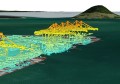
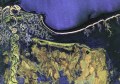
The delineation of the water bodies’ extents internationally is a derivative of producing the global WorldDEM dataset – the first elevation model to provide a truly pole-to-pole coverage with a unique level of detail and quality. Airbus Defence and Space is harnessing this information to produce the ‘WorldDEM Ocean Shoreline’ product which is intended to replace existing global or sub-global shoreline and lower resolution datasets.
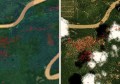
Within the cooperation, Airbus Defence and Space is in charge of producing a Digital Surface Model enforced with water body features derived from radar imagery. CSTARS’ expertise in oceanographic environments is used for additional vector specification by further detailing the shoreline where necessary in respect to any recent temporal changes based on the latest available satellite imagery. (including new ports, marinas, jetties, breakwaters, beach erosion or accretion, etc.)
The resulting “WorldDEM Ocean Shoreline” is (as is WorldDEM) a homogeneous, gap-free and up-to-date database, with a consistent and uniform horizontal resolution of 12 meters. The WorldDEM product range is based on the global TanDEM-X DEM as generated by the TanDEM-X mission, which is performed jointly with the German Aerospace Center (DLR).