Researchers say the work demonstrates AI’s potential to expand GIS and apply it in innovative ways.
A team led by geography researchers at Penn State University has built and tested AI-powered GIS agents in order to introduce a conceptual framework of autonomous GIS, and to examine how the AI paradigm shift is redefining the practice of GIS.
Using four proof-of-concept agents, the researchers showed that they can retrieve geospatial data, perform spatial analysis and generate maps with minimal human intervention.
“Just like the paradigm shifts of the past, autonomous GIS represents an emerging paradigm of integrating AI with GIS, where it is not just another tool but instead becomes an artificial geospatial analyst able to use GIS tools to solve geospatial problems,” said lead author Zhenlong Li, associate professor of geography in the College of Earth and Mineral Sciences and director of the Geoinformation and Big Data Research Lab.
“In this study, we spent time exploring, as a GIS community, how to best integrate AI ‘agent’ technology into existing GIS workflows, and analyse the current drawbacks and limitations of the systems,” Li said.
“Our goal is to lay the groundwork for the geospatial community to develop GIS systems that move beyond traditional workflows to autonomously reason, derive, innovate and advance geospatial solutions to pressing challenges.”
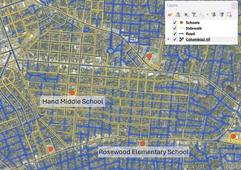
In one of the case studies, the researchers developed a data retrieval agent called LLM-Find, first detailed in the International Journal of Digital Earth, which automatically fetches geospatial datasets based on users’ requests, such as “download road networks excluding footways and service ways for a school walkability assessment in Columbia, South Carolina.”
Within minutes, LLM-Find obtained data on footpaths, roads, school locations and the kind of high-resolution, remote-sensing imagery needed for a complex assessment.
“LLM-Find demonstrated that autonomous GIS agents can handle data acquisition from sources without manual dataset hunting, helping to reduce the grunt work of data preparation in spatial analyses,” Li said.
“But the number of sources the AI agent can consult is still limited, so human oversight and management is needed for LLM-Find.”
Another AI GIS agent, LLM-Geo, assessed school walkability using the data fetched by LLM-Find, then autonomously generated a spatial workflow that produced walkability scores and maps.
“This is a more complex task that goes beyond data retrieval, where the AI agent is actually doing analysis of data based on a plain-language prompt,” Li explained.
“This analysis work might normally be done by a junior or entry-level geographer.”
A further case study, LLM-Cat, completed more rigorous cartographic tasks — going beyond data acquisition and analysis to design visual maps. The agent made decisions on symbols, colour scales, map views and other elements, bringing the whole system closer to full automation.
The fourth case study brought together all three AI GIS agents into a collaborative desktop human-to-agent assistant, GIS Copilot, which works in a similar fashion to that of ChatGPT or Google Gemini.
“We tested GIS Copilot across over 100 multi-step guided spatial tasks and advanced unguided tasks with an overall success rate of about 86%,” Li said.
“Though it still needs human supervision, GIS Copilot shows what is possible for future GIS integration with AI, particularly in allowing non-experts to perform geospatial analysis with limited knowledge of the field.”
Integrating AI into GIS is opening new possibilities, according to co-author Guido Cervone, director of the Penn State Institute for Computational and Data Sciences.
Cervone said that rather than it being a threat to the livelihood of professionals, AI provides many opportunities to grow GIS and apply it in innovative ways.
“In the last five years, we have seen more progress in GIS than I thought I was going to see in my lifetime,” said Cervone, who also is a professor in the Departments of Geography and of Meteorology and Atmospheric Science.
“From a research perspective, AI accelerated our research impact to new levels, as we can now quickly access and analyse data to better study our planet and its natural and built environment.”
Cervone foresees that changes will take place in education, and that it is an exciting time to be a student or a professor in geography and geoinformatics.
“If the recent past is an example, then we will have surprises and be able to achieve tasks that are impossible to even imagine today,” Cervone said.
“This will happen within a generation of our students, and our challenge as professors is to train them to be part of the AI and computing revolution and prepare them for new challenges and innovative solutions.”
The work on AI GIS agents has been published in the Annals of GIS.