A New Zealand start-up is providing InSAR-based ground movement reports for those in the property market.
Land movement is a growing problem for New Zealand homeowners. In the five years to May 2026, the Natural Hazards Commission received almost 13,000 claims for landslide damage, 10,000 more than in the previous five years. Cyclone Gabrielle alone triggered more than 140,000 landslides.
In 2023, and the Ministry for the Environment reported that climate change can make landslides and erosion worse. For homeowners, that can mean cracked houses, damaged sections and hard decisions about whether to buy, build or stay.
Whangārei-based startup Avant says it aims to help people make those decisions, through a new service called LandSure.
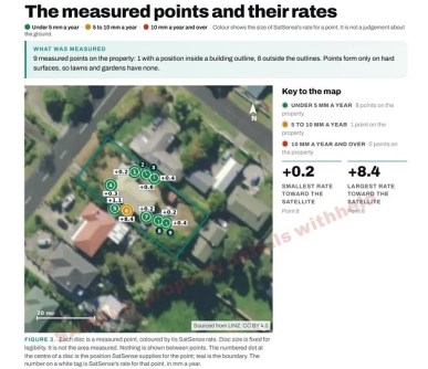
From today, homeowners and buyers can order a satellite ground movement report on a single property from LandSure. The report converts up to about ten years of InSAR measurements for the property into plain English.
Each report combines satellite radar measurements with public records about the property’s land. The measurements come from the Sentinel-1 satellites and are processed by SatSense, the UK company that developed a national ground movement dataset for New Zealand with GNS Science, now part of Earth Sciences New Zealand.
Thus, LandSure produces its InSAR land movement reports in partnership with SatSense and Earth Sciences New Zealand.
Satellite data at your fingertips
Until now, obtaining measured ground movement records for a single home usually meant commissioning specialist work that many owners found hard to justify without clear signs of a problem.
“New Zealanders are inclined to live with a sticking door or cracked driveway rather than pay for an investigation, but small problems can become expensive if left unchecked,” said Josh McKenty, founder of Avant.
SatSense states an accuracy of about 1 mm a year for a point’s average rate of movement. The radar measures hard surfaces such as roofs and paving, so not every property has measurement points. A free check at landsure.ai shows whether a property has them before a report is ordered.
“New Zealand has some of the most dynamic ground in the world, which makes it an ideal place to show what this technology can do,” said Dr Matthew Bray, CEO of SatSense.
“LandSure has taken a dataset built for specialists and made it genuinely useful to homeowners and buyers.”
“People don’t need to be experts in satellite radar to benefit from it. What they need is a clear picture of whether their property or the ground beneath it has been moving, and a sensible next step if it has,” added Dr Jennifer Scoular, Head of Product at SatSense.
The report is designed to help owners and buyers decide whether to investigate further before committing to a purchase, subdivision, extension or second storey.
“The report does not replace a geotechnical engineer. It gives an owner or buyer an accessible first look at what is happening so, if there is an issue, they can engage an engineer to determine why,” said McKenty.