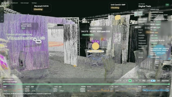
The UQ VisLab spatial twin combines 3D scanning, point clouds and arrays of environmental and spatial sensors.
The University of Queensland (UQ) VisLab is developing new spatial twin research that investigates how the qualities of occupied environments can be captured, monitored and understood through integrated spatial data.
The research, led by Dr Qianbin Xu and Associate Professor Fred Fialho Teixeira, extends the laboratory’s work in digital twins by bringing together detailed representations of physical space with live information about environmental conditions and patterns of occupation.
The spatial twin combines multiple spatial capture technologies, including 3D scanning, point clouds and arrays of environmental and spatial sensors.
Live data streams can record temperature, humidity, CO2, sound, light and proximity alongside detailed three dimensional representations of the environment.
These datasets are integrated within an interactive spatial interface, allowing researchers to examine changing environmental conditions in direct relation to where they occur.
Rather than separating sensor readings from the spaces they describe, the Spatial Twin positions environmental information within its physical context.
The spatial twin is also being developed as a decision support tool for researchers, designers and facility managers. By combining real time data integration, spatial visualisation, environmental sensing and temporal analysis, the platform can help identify patterns, compare conditions and evaluate alternative spatial or operational responses.
This creates opportunities to move from monitoring existing conditions towards evidence informed decisions about building performance, space use and occupant wellbeing.
The research forms part of the VisLab’s continuing work in spatial intelligence and the relationship between physical and digital environments, building on UQ Digital Twin research.
Related reading: