
New geospatial sector market research out of the UK has offered a glimpse into the state of geospatial intelligence adoption.
Conducted by Landmark Information Group, the market survey shows that, overall, geospatial intelligence is changing from being a niche capability to a vital part of businesses’ infrastructure.
“Over the past year in particular, organisations have seen a clear rise in demand for geospatial outputs, with more than eight in ten professionals (83%) reporting an increase in demand compared with 12 months ago,” said Josh Rains, Managing Director of Landmark Geodata.
“Yet as this demand scales, so too does the complexity of delivering against it,” he added, with 78% of respondents saying that demand is outpacing the ability to deliver.
“While nearly all organisations (94%) expect geospatial insight to play a greater role in decision-making over the next two to three years, embedding it effectively across workflows, systems and teams is proving significantly more challenging,” said Rains.
Geospatial intelligence: Demand versus budgets
According to the research, 30% of respondents reported having well established internal expertise in geospatial intelligence, 29% reported having emerging expertise or in-house tools, while 23% reported being reliant on external services. Only 18% reported having geospatial capability embedded on enterprise-wide strategic platforms.
With regard to demand for geospatial data or analysis, 43% said it has increased significantly, 40% reported a slight increase, 14% said it had stayed about the same, while only 3% reported a decrease. Overall, though, 94% of respondents expect that geospatial insights will be embedded in more decision-making activities within the next two to three years.
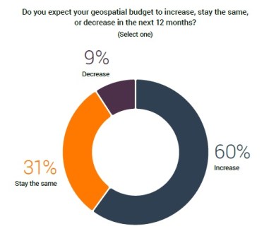
Although 83% of respondents reporting some increase in demand, only 60% expect their geospatial budget to increase over the next 12 months, with 31% expecting it to stay the same and 9% expecting it to fall.
In response to the question of what the single biggest challenge is right now, the two most common reasons cited are data integration (17%) and managing large volumes of data (17%), followed by data quality (14%) and the difficulties of dealing with legacy systems (13%).
When asked what the single biggest ‘blocker’ is to using geospatial data in their organisation, 30% of respondents said integration challenges, followed by data licensing (17%) and price (14%). Only 6% said there is nothing stopping them.
AI adoption is top of the agenda for geospatial
The research also provides insights into the use or potential use of AI, with 68% of organisations already using it within their workflows and another 25% planning to start using it within the next year.
Most (83%) said they use AI for analysis and insight generation, but 47% said they are also starting to use it to support data preparation.
Almost all (88%) GIS professionals think they will use AI to automate workflows within the next few years, with 34% already testing end-to-end automation.
The report goes on to discuss other topics, such as regulation, digital twins, standards and others.
“Overall, the research highlights a market defined by strong momentum and passionate people but also by structural constraints that must be addressed if the full value of geospatial is to be realised,” said Rains.