

Back in 1986, a small team put $90,000 GPS receivers to the test during a survey in the western districts of Victoria.
By Peter Terrett
This month marks the 40th anniversary of the first GPS survey undertaken in Victoria. For me it does not seem like all that long ago, but it was likely before many Spatial Source readers were born. It affected my life far more than most.
The project was undertaken by the geodetic and topographic survey section of the Division of Survey and Mapping under the Surveyor-General in the Victorian Department of Crown Lands and Survey.
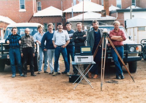
Seven Division staff were involved, plus an observer from RMIT. The project leader was Peter Letherby, a contractor from Canada who also provided the three, $90,000 (1986 dollars) Trimble 4000S receivers.
It is my understanding that two other projects had been done earlier by the same contractor prior to the Victorian project: one in the Northern Territory and one at or near Broken Hill in NSW.
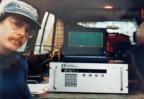
The specifications of that early Trimble receiver are very different to today’s technology. It had four channels on only the L1 frequency, with only post-processed differential GPS available. It was heavy, had a 19-inch rack format enclosure, and required a vehicle’s (Land Cruiser) battery to run. We used a laptop with no hard drive and only 640 KB of RAM and a 360KB floppy drive; MS-DOS 3.0 had to be loaded on every start-up.
Putting GPS to work
The project kicked off on Monday, 5 May 1986 with an initial hands-on lesson at Studley Park, about five kilometres east of the Melbourne CBD. I was very excited to be the first to log in and connect to the GPS constellation. Because there were so few satellites in orbit, we had to come in early to catch enough of them in view to do the training.
The base for the GPS survey project was Casterton in the far west of the state. The project’s aim was to densify the trig network in what was very flat and timbered country that was very unsuitable (expensive) for traditional control surveys. The opportunity was to place controls in areas that would also be suitable for photo control for the 1:25,000 mapping program. The extent of the project was from south of Hamilton and north to Edenhope, and to the South Australian border.
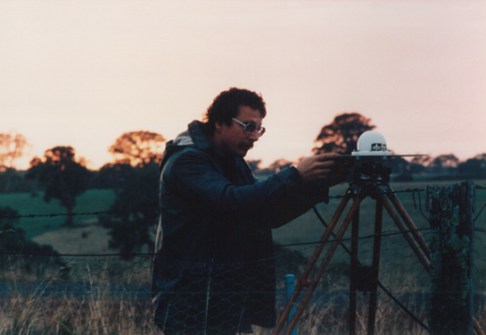
We had to leave by about 3:30am to be on-site for the first of two available ‘windows’ with either five or six satellites in total that were 10 degrees or greater above the horizon. After setting up, all three stations would record at the same time for at least an hour, taking a reading every 15 seconds. Then, two of the three stations would pack up, drive to the next location and do the same thing again. So, we could create up to four new trigs each day.
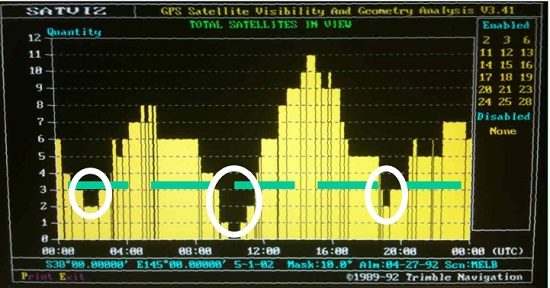
I don’t have a satellite prediction from that project in 1986; the earliest one I have is from 1992 (see below). It shows that there were three periods throughout the day where no position was possible.
I was involved in the post processing of the data. Each observation period produced three lines — station 1 to 2, 1 to 3 and 2 to 3. Each line would take around 25 to 30 minutes to compute, so the six lines for the day meant an additional 3 hours.
A new reality
I was truly fascinated by the technology and took every opportunity to be involved after our department bought two GPS receivers. RMIT also purchased an identical one. We had them for eight months of the year and RMIT had them for four months.
I never imagined that GPS would become so normal in our daily lives and that such amazing innovation would drive a widespread adoption into our mobile phones, cars and businesses. The acceptance by subject matter experts in fields like sub-surface assets, geophysics, forestry, transportation, archaeology and so on, has driven the costs down and increased the value of data… all while going from an accuracy of real-time 100 metres to real-time 10 mm.
For me, I went into business in 1991 to sell, support, train and consult on GPS, which, with the addition of the Russian GLONASS, European Galileo and Chinese BeiDou, has become the GNSS (Global Navigation Satellite System). There are also two regional systems — the Japanese QZSS and Indian IRNSS (aka NavIC). Although my business has grown and evolved into spatial services and software development, I spend most of my day still directly involved in GNSS sales and support.
If you have an interest in GNSS and want to learn more about its early development, have a look at the video below. I highly recommend this documentary about the weekend when GPS was designed.
Peter Terrett is the founder of 4D Global. You can contact him at pterrett@4dglobal.com.au.


