

A new report from the United Nations University’s Centre for Policy Research investigates three sectors that are being transformed by AI, including the geospatial sector.
The report covers geospatial case studies presented at the AI for Good Conference 2025, along with others from the robotics and telecommunications sectors.
“Whether it’s supporting rehabilitation, disaster response or strengthening early warning systems, the use cases in this report show what’s possible when innovation is guided by public purpose, shared values and multi-stakeholder cooperation,” writes Doreen Bogdan-Martin, Secretary-General of the International Telecommunication Union, in the report’s foreword.
Faster data
One of the geospatial AI examples given is the application of SATGPT, a combination of ChatGPT and the Google Earth Engine.
It cites an example presented by Hamid Mehmood from the Space Applications Section at the UN Economic and Social Commission for Asia and the Pacific, during an AI for Good webinar.
According to Mehmood, SATGPT users can produce historical flood maps (from 1984 to the present) in as little as 15 to 30 seconds using a simple natural language command such as “map the 2010 flood in North Bangkok”.
“Through optimising geo-prompt engineering, SATGPT addresses global flood monitoring challenges with 82 per cent accuracy, providing consistent AI-generated outputs by including persona, language, functionality, context, sensor specifications and visualisation parameters in prompts,” the report says.
“This approach reduces hallucinations and enhances transparency by allowing users to download and verify the underlying Google Earth Engine code. In addition to flood mapping, SATGPT also helps to monitor wildfires, droughts and tsunamis.”
Geospatial for good
The report makes the case for the importance of geospatial data in solving some of the world’s most pressing problems, such as hunger. It quotes figures from the World Food Programme, which estimates that around 343 million people in 74 countries are facing acute hunger, with 1.9 million people experiencing catastrophic hunger.
But geospatial intelligence — specifically geospatial AI — can help.
The report cites the example of the FAO’s geospatial platform, Hand in Hand, which uses “satellite-derived analytics and data to contribute to rural development and to drive digital agricultural transformation. These applications are part of FAO’s broader initiative to harness geospatial technologies for early warning systems and resilience building in agriculture.”
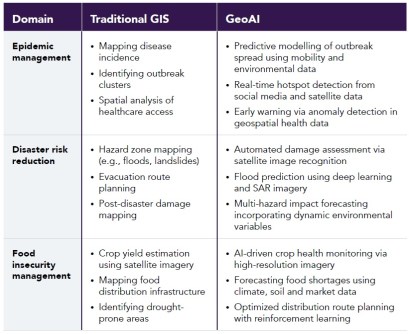
The report also makes the point that geospatial data, which it says makes up about 80 per cent of all data, are “essential for AI development, yet many low- and middle-income countries lack the infrastructure, skills and access to collect, label and manage high-quality data, resulting in exclusion, bias and skewed decision-making.”
This particularly applies in the Global South, where gaps remain in data quality, ethical oversight and equitable access.


