

Our weekly round-up of all the bits and pieces of geospatial news that didn’t make it into our normal daily coverage.
If you have a Spatial Snippet to share with our readers , please send us an email.
Apologies for the late notice on this one, but we’ve only just learnt about it. Current domestic students enrolled in Curtin University’s Bachelor of Mine and Engineering Surveying or Bachelor of Surveying (Honours) courses, can apply for one of two MNG scholarships. The application deadline for both scholarships is today, 4 March, and they are:
- The MNG Scholarship for Women in Surveying, which provides $3,000 per annum for up to four years plus guaranteed paid vacation work. Details here.
- The MNG Surveying Scholarship, which provides $5,000 for one year plus guaranteed paid vacation work. Details here.
Victoria’s Department of Transport and Planning has an opening for a full-time Senior GIS and Database Systems Officer, based in Melbourne. The role involves providing technical support and enhancement for digital land information systems, delivering GIS, FME and back-end system support to the Declaration and Land Information team. Applications close on 12 March.
In NSW, DCS Spatial Services has an opening for a full-time Spatial Technician. The role involves undertaking a range of activities related to the sourcing, quality assurance, maintenance and delivery of Spatial Services’ Foundation Spatial Data. This includes cadastral, topographic, addressing, surveying, elevation and imagery information. Applications close 10 March.
Queensland’s Department of Transport and Main Roads has a vacancy for a PO3 Surveyor. To be based in Townsville, the successful applicant will manage diverse engineering survey projects and provide expert geospatial services. Applications close 20 March.
Also in Queensland, the government is seeking an experienced professional to act as a Principal Spatial Analyst in the Spatial Analytics and Mapping Unit. Duties will involve producing mapping products and sourcing, transforming and analysing spatial data to support land use and infrastructure planning at both regional and local levels. Applications close 17 March.
And still in Queensland, the government is looking for a Principal GIS Analyst to join the Biodiversity Assessment team, based at Dutton Park. The team is responsible for the delivery of key state-wide planning tools and assessments through products such as the Biodiversity Planning Assessments, Aquatic Conservation Assessments and habitat suitability mapping. Applications close 17 March.
A hydrographic surveying/ocean mapping course will be held in Hobart in May. The six-day course — part of outreach from the Universities of New Hampshire, US, and New Brunswick, Canada, and co-hosted by CSIRO and Acoustic Imaging — will be held in Australia for the first time since 2018. This internationally recognised course will provide opportunity and access for those in the local hydrographic survey community who are unable to travel to North America or Europe. Details here.
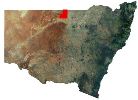
In NSW, DCS Spatial Services has released 12 new batches of high-accuracy LiDAR-derived elevation data, covering more than 6,000 square kilometres, available freely via the ELVIS portal. The areas covered are: Blayney, Richmond Valley, Bourke, Brewarrina, Paroo, Balonne, Bega Valley, Maitland, Cessnock, Cabonne, Upper Hunter, Liverpool Plains, Walgett, Narrabri, Lismore and Coffs Harbour.
In Western Australia, the government has announced the availability of $4 million in grant funding for coastal planning, management and hazard mitigation programs. Eligible initiatives might include education and conversation programs, and coastal erosion hotspot measures. But of particular interest for some Spatial Source readers might be the Coastal Management Plan Assistance Program, which assists coastal land managers in preparing and implementing strategies and management plans. Grant applications close 15 April.
The inaugural National EISSI Awards will be held on Thursday, 23 April 2026 at The Marion in Canberra. These national awards will draw their nominees from the state- and territory-based awards that were held last year. In fact, 2025 was the first time the awards reached beyond NSW, taking in Victoria, Western Australia, Queensland, Tasmania and the Northern Territory. Registration details can be found here.
A reminder that early bird registration rates for all-access passes for the Geo Connect Asia conference and exhibition, are available until 20 March. Geo Connect Asia will be held at the Sands Expo & Convention Centre, Singapore on 31 March and 1 April, covering the geospatial, location intelligence, autonomy and uncrewed sectors.
Similarly, early bird registration for the upcoming ISPRS Congress in Toronto, Canada (4 to 11 July) has been extended until midnight on 9 March, North American Eastern Standard Time.
Make sure you don’t miss out any geospatial news from across Australia and around the world — subscribe to our free Spatial Source newsletter, sent out every Wednesday and Friday morning.


