

Image courtesy FireFlight
The South Australia Government is supporting the trial of an airborne, real-time, fire-mapping system during this year’s fire season to help better protect communities in bushfire prone areas.
“This technology offers the possibility of improving how we respond to and control the threat posed by bushfires, better protecting people and property in bushfire prone areas,” said Minister for Innovation and Skills David Pisoni.
FireFlight Technologies — a startup based at the University of South Australia’s Innovation and Collaboration Centre — has received $100,000 in funding from the state government to trial its FireFlight system with the Country Fire Service (CFS).
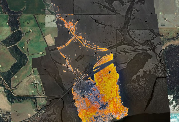
The FireFlight sensor system is mounted on a manned aircraft that is flown over an active bushfire.
It takes less than a minute to fly over the fire front, create the map of the fire and deliver it to the firefighting agency, enabling it to accurately track the fire’s path and potentially limit its destruction.
FireFlight Technologies founder and chief executive officer, Dr Paul Dare, said the system had proved valuable to firefighting agencies during trials in Queensland and Tasmania, and the SA trial will be the first full, season-long trial of the system in Australia.
“The FireFlight system will deliver real-time fire intelligence to incident controllers, helping them to efficiently deploy resources such as firefighters, fire trucks and firebombers where they are really needed,” Dr Dare said.
“The fire maps provided by the FireFlight system will show exactly where the fire is at that moment.
“The maps can be updated on a minute-by-minute basis, enabling the CFS to monitor the progression of the fire and better understand its behaviour.
“The length of the trial will enable us to make changes to the system during the season, based on feedback from the CFS, so that we can ensure we are meeting their needs.”
Stay up to date by getting stories like this delivered to your inbox.
Sign up to receive our free weekly Spatial Source newsletter.


