

Comparison of a Semantic LOD and 3D Mesh model
Mr. Fabrice Marre, Geospatial Innovation Manager, Aerometrex
Digital twins are an accurate and up-to-date replica of real entities and are at the heart of smart city initiatives. They are made of interconnected static & dynamic layers of geospatial data and information. These provide a virtual 3D environment to develop, visualise and test scenarios to make informed decisions before real-world implementation.
A 3D city model is a digital representation of an urban area and provides a fundamental building block for digital twins. They can be consumed offline and online using interactive 3D platforms and provide a wide range of analytical and visualisation tools to support smart city operations.
3D mesh and semantic models
3D city models come in two distinct forms with their own characteristics and usage scenarios – semantic and mesh models.
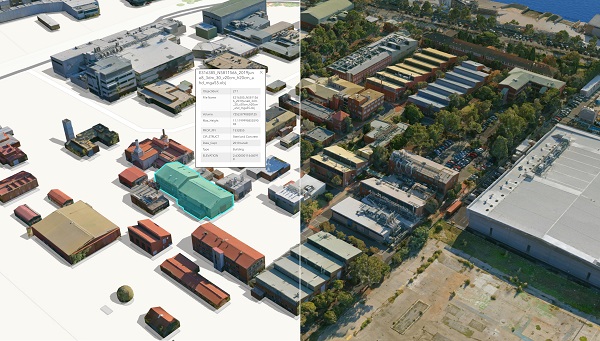
Semantic 3D models are composed of individual 3D objects represented by simple geometry and rich information. In these models, buildings can be modelled at different levels of detail (LOD), from simple block models to ones with more complex geometry, such as roof structure, verandahs, and chimneys. The visual appearance of these buildings can be enhanced by using texture derived from ground or aerial imagery.
Example of a classified 3D mesh model with individual building attributes
3D mesh models are generated using photogrammetry techniques and can be produced with exceptionally realistic visual quality and accuracy. These models usually include all objects present in a scene, but individual objects are not separate entities and are part of a continuous mesh. Aerometrex has developed an AI-powered solution to automatically segment and classify objects within a 3D mesh and derived point-clouds. A photorealistic, location-accurate 3D mesh with classified individual objects takes this product to the next level by offering rich analytic capabilities. These classified 3D mesh models are now supported by a growing number of 3D platforms including Cesium, Skyline TerraExplorer and soon, ArcGIS Pro.
Some cities are adopting a dual 3D model approach, where the same source of imagery is used to produce both a 3D semantic and mesh model. Aerometrex has provided such dual 3D models to clients including the Victorian State Government’s Fisherman’s Bend Digital Twin, where in addition to the 3D mesh, LOD2 buildings were digitised and textured using 2cm helicopter imagery.
Seamless multi-scale 3D mesh
Smart city applications often require 3D data at more than one resolution therefore a multiscale approach is necessary. A multiscale approach is the seamless integration of data captured from different platforms, at different resolutions. Aerometrex routinely generates multiscale 3D mesh from aerial imagery captured, via fixed wing aircraft, helicopter and at ground level, with resolution ranging from few cm down to a few mm.
Aerometrex recently delivered a multiscale 3D mesh model for the Sunshine Coast Council and the QLD DNRME, including a 750 sq. km model captured at 7.5cm resolution, a 17 sq. km model captured at 2cm and a 2.5 km street-level model. Internationally, Aerometrex has processed a seamless 3D mesh model of the City of Pau in France using a combination of helicopter and street-level capture, a first at that scale in Europe.
Some applications
Adopting a smart city approach, with 3D city models as the base, provides huge economic benefits to towns and cities, especially in town planning and urban design. Using interactive 3D platforms, architects and planners can better understand new building design in context, assess their impact and restrictions, anticipate urban developments, and communicate findings to stakeholders in a very intuitive way. Other applications of 3D models are seen across areas such as event planning, risk management and urban logistics. 3D models can also be realised using game engines such as Unreal Engine and Unity to offer ultra-realistic immersive experiences like never-before.
We live in a dynamic environment and being able to analyse changes to our urban landscapes over time provides decision makers with invaluable information. Aerometrex captures and generates 3D mesh models on a regular basis and provides change analysis information.
Information provided by Aerometrex


