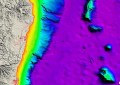
In June this year, huge waves and king tides combined to drive Collaroy Beach back 50 metres. The worst of the damage, shown here, was surveyed by RPAS by researchers of the UNSW Water Research Laboratory.
This is the second in a 2-part article written by Jon Fairall and originally published in the Aug/Sep 2016 Issue of Position magazine. If you haven’t already, please read part 1 to learn of the growing problem of erosion and sea level rise, as well as the solution—if any—spatial innovation has to offer.
Sea level rise may well be negligible out to the current planning horizon, but the evidence seems to be that more extreme weather is already upon us.
Ill-conceived planning decisions in Cairns will likely make for a perfect storm in coming years. The delta of the Barron River used to be a nest of mud flats and mangroves. Today it has been covered by suburbia, lined with seawalls.
Professor Andrew Short of Sydney University says the problem there is “both the river, which has major floods and accompanying pulses of sediment, and the coast, which is exposed to periodic tropical cyclones.”
“Roads and houses have been built on parts of the coast which will periodically be reclaimed by the sea, as well as periodically protected by wide beaches,” he said.
The Gold Coast is also under threat. Something like half a million cubic metres of sand per annum is entrained by the coastal currents. Local and state governments have engaged in expensive civil works to try to stop the inevitable conflict between the beach and the city at a cost in the tens of millions of dollars.

The erosion at Collaroy following the devastating June storms.
Up and down the NSW coast, there are plenty of examples of inappropriate coastal works which have changed shoreline dynamics and led to the destruction of entire villages. Who remembers Sheltering Palms, the ironically named village that disappeared in the 1970s?
Much of the Victorian coast is protected by a foreshore reserve, but the same iron rule of nature applies. In the 1960s, city fathers organised a breakwater to protect Portland. It interrupted the movement of sand, the reserve was eroded and a seawall, now 4.5 km long, has been constructed at great expense.
Problems of foreshore maintenance continue in Adelaide. Pollution has destroyed seagrass meadows, which has increased the rate at which currents are exporting sand from the beaches. It’s being managed by the construction of 14 kilometres of seawalls and massive artificial movement of sand, which has resulted in new dunes at Brighton, but at significant cost.
Only more to come
In 1990, the South Australian government voted to freehold hundreds of beach shacks, many built close to or on the beaches and in low lying erosion and flood-prone areas. Andrew Short blames politicians for ensuring that South Australia has generations of coastal problems. “It will be up to the taxpayers to maintain these unsightly ribbon developments and to try and protect these properties as they become increasingly exposed to shoreline erosion and sea level rise”.
“In contrast the Western Australian government has removed many hundreds of beach and fishing shacks that dotted the coast north of Perth as far as Geraldton. These have been removed along with the associated myriad of 4WD tracks and replaced by coastal reserves with well-planned and designed access points along the coast, while neighbouring coastal towns are being developed as nodes for the increasing coastal population.”
To get stories like this delivered to your mailbox every week, subscribe to our weekly newsletter.
No matter how you slice and dice the problem, clearly, any number of citizens will, in the no-too-distant future, be facing a calamity and their lawyers will be looking for someone to sue. A number of lawyers have argued that under certain circumstances, shore line erosion and the Doctrine of Accretion could amount to compulsory acquisition by the Crown, triggering Just Compensation provisions in various state and federal laws.
But in a recent paper, John Corkill, a member of the Coastal Council of NSW, argues that the current state of the law protects local government agencies from litigation by property owners due to MHWM ambulation, provided that the council has made its planning decisions in ‘good faith’.
That raises the question, of course, of what constitutes good faith. At least one component of this is the need to be well-informed. It’s vital for local government planners to understand the processes that affect the coastline. The good news is that over the last seven years, state agencies, Geoscience Australia and industrial partners have measured the height of every point in coastal Australia to provide, for the first time, an accurate prediction of how communities and infrastructure will be affected by floods and rising sea levels.
The Urban Digital Elevation Model and an earlier project, the Coastal Urban Digital Elevation project, combined data from 230 individual aerial surveys to create a seamless database that describes nearly all of Australia’s coastal and riverine floodplains. In all, it covers 250,000 square kilometres. This vast region is described in the computer by a network of points five metres apart. The height of each point is known to within 15 cm. It is the largest dataset of its type in the world.
In the face of all available data, unscrupulous developers will continue to build housing on beach fronts and gullible buyers will continue to buy it.”
This raises a significant question: will an accurate digital elevation model make a difference? It is ironic, for instance, that Collaroy Beach is probably the most studied beach in Australia. Since 1976 there has been an on-going surveying program, initiated by Professor Short and run since 2004 by the Water Research Laboratory. Three reports were written by WRL for the then local government—Warringah Council—between 2005 and 2007 to provide an analysis of shoreline variability and trends on the Collaroy-Narrabeen complex. Even so, the local government appears paralysed by inappropriate planning and shoreline subdivision that took place more than 100 years ago as well as by community opposition to every remedy under consideration.
The original property boundaries extended across the dunes onto the beach. Every time the beach retreated, the beach shacks were undermined. Major erosion occurred in 1920. Seven shacks fell into the sea in 1944-5, and one was washed out to sea in 1967. Following the 1945 storms the council voted to resume the remaining houses. Instead, within ten years the first block of flats was built. The first high rise was undermined by the 1967 storms. More high rises followed and were duly undermined in 1974.
Looking for an answer
To a large extent, the usefulness of surveying data and the provision of information on beach processes depend on how easy it is for officials in local and state government agencies to obtain the relevant data for their area and apply it intelligently. To that end, an important component of work by the Cooperative Research Centre for Spatial Information (CRCSI) in relation to the new surveys was the specification of consistent access, distribution and usage agreements between the parties.
Some of this work involves the creation of a national portal where people can access data on littoral morphology and plot the effect of inundation due to sea level rise, king tides or storm surges. They have developed tools that assess coastal risk using Google Earth.

Coastal Risk Australia by NGIS maps expected sea level rise across Australia, including Byron Bay shown here with expected inundation by 2100.
CRCSI says the investment in the project has led to a step change in the techniques used to create the data and in the way the Australian community can access and use the information it contains.
A new information gateway has been created called the National Elevation Data Framework. It includes the Elevation Information System (ELVIS) which is designed to ensure “decision makers, investors and the community have access to the best available elevation data describing Australia’s landforms and sea bed to address the needs of today and the decades ahead.”
Earlier this year, NGIS made the process even easier with their browser-based Coastal Risk Australia tool, which allows just about anyone with an internet connection to visualise how sea level rise driven by various climate change models will impact their area. Such was the ease of use of the tool, that it made headlines on Huffington Post Australia, SBS and News.com.au.
However, if history is any guide, it will not be enough. In the face of all available data, unscrupulous developers will continue to build housing on beach fronts and gullible buyers will continue to buy it. The question remains whether taxpayers will be prepared to pick up the pieces.