

Port Stephens Council on the NSW North Coast, is most of the way through preparing a new, comprehensive map of vegetation types across its local government area.
The aim is to provide landowners with information on what kind of native vegetation might be on their properties, which will be useful or even essential for planning land use, for conservation planning and for conducting biodiversity assessments.
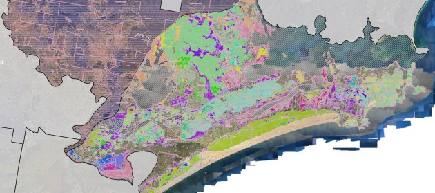
The map is being prepared in three phases, with the first two (to the east of the M1 motorway) already completed to draft stage and available on the Council’s website. The third stage, west of the M1, is underway and due for completion in December 2025.
The map displays vegetation classified into 30 plant community types, from various types of forests (e.g. dry, littoral, alluvial) to heaths, scrubs (e.g. estuarine paperbark, coastal sand), thickets and woodlands.
Data has been obtained from a variety of sources, such as existing vegetation and mapping data, aerial imagery, soil maps, land topography and hydrology data, and information about past land use or clearing.
The work has also involved undertaking more than 15,000 site-based surveys.
The process has involved first estimating the state of the native vegetation prior to European settlement and then updating that data to indicate the current state of native vegetation.
According to the Council, “Vegetation Mapping is a valuable tool that will support biodiversity assessments, conservation planning, and land management activities, and will assist in reducing risks, costs, and timeframes for both Council activities and development applications”.
“It helps Council enhance the effectiveness of its land management activities and provides landscape-scale information for land managers in the region.”
Draft vegetation mapping spatial data files can be obtained by emailing Environmentalplanningteam@portstephens.nsw.gov.au.
A supporting report (PDF) can be downloaded here.
In related news, the Council is also in the final stages of preparing an updated Koala Habitat Map, since the current map is more than 20 years old.
“The updated koala habitat mapping will help inform decisions, guide policy changes and assist in streamlining development assessment requirements in Port Stephens — all with the aim of keeping our koala population protected,” said Mayor Leah Anderson, who is also Chair of Council’s Comprehensive Koala Plan of Management Committee.
“With advancements in mapping technology and survey methods, alongside on-ground changes in habitat and koala population extents, it’s time we reviewed this map to ensure we’ve got the most up-to-date information.”
As part of the process, the Council conducted targeted koala surveys at more than 250 locations from April to October this year.
That survey will be combined with the vegetation mapping data to produce a draft Koala Habitat Map by December 2025, with the final product expected to be released in May 2026.


