

Researchers from Chiba University in Japan have created a data-driven spatial framework that assesses where ‘vertical greenery’ is most needed or most effective.
Vertical greening is the placement of vegetation on building façades, seen by some as a viable way of reintroducing nature into crowded urban settings.
The new research has been used to identify the best locations for vertical greening throughout Tokyo’s 23 wards.
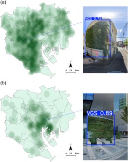
The study, published in the journal Sustainable Cities and Society, provides the first citywide map of vertical greenery in one of the world’s densest metropolitan areas.
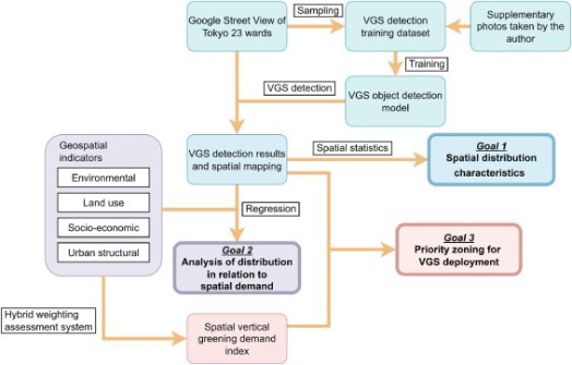
The research team — led by Professor Katsunori Furuya, along with Ms Ruochen Ma, Ms Yunchen Xu, Ms Yan Tang, Mr Sihan Zhang and Ms Yuhui Liao from the Graduate School of Horticulture, Chiba University — used AI to analyse more than 80,000 Google Street View images.
Using a deep-learning model (YOLOv8), they detected façades featuring vegetation, such as green walls and balcony plants, to create a detailed spatial inventory of Tokyo’s vertical greening systems.
“With this study, we aimed to provide a clearer picture of how vertical greenery is distributed in dense urban areas like Tokyo and how it aligns—or fails to align—with environmental needs,” said Professor Furuya.
“By combining AI-based image analysis with spatial data, we can now pinpoint where greening efforts could make the greatest difference.”
The researchers introduced a new metric called the vertical greening demand index (VGDI), which evaluates where additional greening could reduce urban heat most effectively and improve environmental quality.
The VGDI integrates multiple factors, such as land use, building density, surface temperature and pedestrian exposure to heat.
Their findings revealed an uneven distribution of vertical greenery across the city.
While commercial and residential zones in central Tokyo had some vegetated façades, several heat-prone and lower-income neighbourhoods had far less greenery, highlighting the need for a more equitable distribution.
The team also identified ‘priority greening zones,’ where adding vertical vegetation could reduce surface temperatures and improve thermal comfort for residents.
“Our analysis shows that vertical greening is not just an architectural feature—it’s an environmental necessity,” says Professor Furuya.
“With data-driven planning, city authorities can target specific areas to enhance cooling, biodiversity, and overall urban resilience.”
The framework’s implications extend beyond Tokyo. As compact cities around the world face rising temperatures and limited ground space, similar data-driven tools can guide the selection of sites for vertical greening to achieve maximum benefit.
Policymakers can use indices like the VGDI to inform building regulations, urban renewal projects and greening incentive programs.
In the long run, such approaches could reshape how cities address the growing challenges of climate change.
“Expanding greenery within existing built environments is one of the most urgent urban challenges today,” adds Prof. Furuya.
“Over the next decade, combining AI and spatial analysis will help governments and designers plan greener, cooler and more liveable cities.”


