

Courtesy NGA
The US National Geospatial-Intelligence Agency (NGA), in partnership with Oak Ridge National Laboratory, has begun offering its LandScan Global and LandScan High-Definition data sets free, without restrictions, to the public for the first time since their initial publication in 1999.
The public availability of these foundational human geography population datasets will help institutions plan for and respond to emergencies, assess human health and security risks, conduct site suitability studies, and a range of other applications that depend on accurate population data.
“Understanding the geographic distribution of populations is critically important, both in times of crisis and in the development of informed strategies for the future,” said Roger Marin, director of the office of geography at NGA.
Offering LandScan Global and LandScan High Definition for free allows U.S. government entities to share and work off of the same data as nongovernmental organisations and local authorities, said Marin.
“This will strengthen NGA’s partnerships with existing customers, while also exposing NGA to new customers with whom we can continue to advance the GEOINT mission,” said Marin.
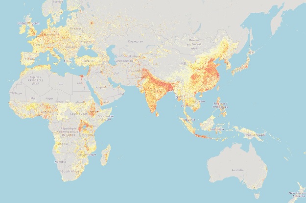
LandScan Global provides a global population distribution dataset with about a 1-kilometre resolution, representing a 24-hour average population.
LandScan HD provides about a 90-metre resolution population distribution dataset for select areas around the world. It is tailored to the unique geography and data conditions of individual cities, countries or regions.
LandScan USA is a gridded population dataset with demographic attribution representing daytime and night-time populations through incorporated census data at the block level at about a 90-metre resolution.
Both LandScan Global and LandScan HD incorporate current land use and infrastructure data from a variety of sources, apply occupancy estimates from Oak Ridge National Laboratory’s population density tables project, and leverage novel image processing algorithms developed at ORNL to rapidly map structures and neighbourhood areas using high-performance computers.
To download LandScan Global or LandScan HD, visit the ORNL portal.
Stay up to date by getting stories like this delivered to your inbox.
Sign up to receive our free weekly Spatial Source newsletter.


