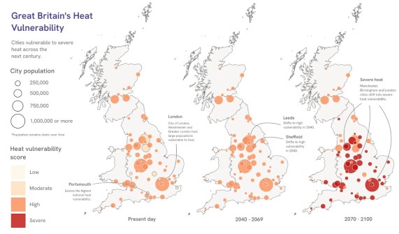
Analysis shows that 8 in 10 cities in Great Britain are vulnerable to the urban heat island effect, with the problem only set to grow worse.
Following a northern summer of record temperatures and heatwaves, new analysis from Ordnance Survey (OS) has found more than 8 in 10 cities in Great Britain are already highly vulnerable to urban heat islands.
But the situation is set to grow even worse, with almost two thirds of cities set to reach severe heat vulnerability by the turn of the century.
And the problem is not confined to cities such as London, but other cities such as Portsmouth will be particularly vulnerable.
Among those projected to warm most between the present day and 2070 to 2100 are Leicester, Exeter, Nottingham, Brighton and Bristol.
Urban heat islands form where dense buildings, roads and hard surfaces absorb solar heat during the day, keeping cities significantly warmer than surrounding countryside.
Unlike rural areas, which cool rapidly after sunset, cities retain the same heat overnight.
Tall buildings and narrow streets reduce wind speeds that would otherwise carry heat away, while a lack of trees and water sources eliminate the natural cooling effects of shading and evaporation.
Where cities lack sufficient green and blue space to moderate temperatures, this effect intensifies throughout both day and night.
By 2040, every city will be in the high vulnerability category
Drawing on its detailed mapping of Britain’s built and natural environment, OS analysed data including building density and height, hard surface coverage, tree canopy, open vegetation and water across every city in England, Scotland and Wales.
OS combined this with satellite readings (from 4 Earth Intelligence) on observed land surface temperatures compared to their surrounding natural environments, and Met Office climate modelling air temperature projections.
The result is a Heat Vulnerability Index tracking how each city’s heat exposure is projected to evolve through to the end of the century, and how effective current sources of natural cooling are in releasing extreme retained heat.
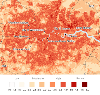
OS analysis finds that 83% of Britain’s cities (59 cities) are already highly vulnerable to urban heat, with the remaining 17% (12 cities) classed as moderately vulnerable today.
By 2040, rising summer temperatures are projected to push every city into the high vulnerability category, and by the turn of the century 63% (45 cities) are set to cross into severe heat vulnerability, the most serious level in the Index.
The consequences extend far beyond uncomfortable summer days. Urban heat can increase risks to health, particularly for older and vulnerable people, while putting additional pressure on homes, workplaces, transport, energy infrastructure and public services.
“These findings matter because cities are where millions of people live, work and spend their everyday lives,” said Nick Bolton, Chief Executive Officer at Ordnance Survey.
“The OS Heat Vulnerability Index shows that by 2040, every city in Great Britain is projected to reach high vulnerability, and by the turn of the century, almost two-thirds could reach the most severe level.
“Understanding how and where this vulnerability is changing depends on an accurate view of how the country is built, based on trusted authoritative data, which is critical for planners, developers and local authorities preparing for a warmer future.”