

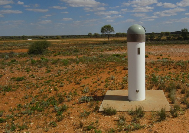
The CORSnet-NSW station at Tibooburra. All images courtesy DCS Spatial Services.
How AUSPOS solutions are being used to help maintain and improve the NSW survey control network.
By Volker Janssen and Simon McElroy
AUSPOS is Geoscience Australia’s free, cloud-based, online GPS processing service. Its uptake and use worldwide, by new users and dedicated fans, continues to accelerate.
AUSPOS has repeatedly proven its capability and reliability, with more than 270,000 jobs processed in just the first 18 months after the current version 2.4 was released in August 2020 and more than 1 million jobs processed in the decade prior. Following the recent release of ITRF2020, a new AUSPOS version is planned for later this year.
Recognising this tool’s importance, Continuously Operating Reference Station (CORS) networks such as CORSnet-NSW contribute to AUSPOS and more than 12,000 AUSPOS solutions have been used to-date in the NSW survey control network.
This article provides a look under the AUSPOS bonnet and outlines how industry-observed AUSPOS datasets can help maintain and improve the NSW survey control network and the Survey Control Information Management System (SCIMS, the state’s database containing more than 250,000 survey marks on public record).
AUSPOS in brief
AUSPOS accepts static, dual-frequency GPS data of at least 1 hour duration (recommended minimum 2 hours, maximum 7 consecutive days) in Receiver Independent Exchange (RINEX) format.
While the submitted RINEX file may contain data from multiple GNSS constellations, only GPS data is used for processing and thinned to a 30-second epoch interval regardless of the initial sampling rate. The user’s antenna type is selected from a drop-down menu, and the height of instrument (measured vertically from the ground mark to the Antenna Reference Point, ARP) is specified.
AUSPOS uses the International GNSS Service (IGS) core network station data and products (e.g. final, rapid or ultra-rapid orbits depending on availability) together with local CORS to compute precise coordinates based on up to 15 surrounding CORS. These CORS are subject to the Regulation 13 certification process, providing legal traceability with respect to the Recognised-Value Standard (RVS) of measurement of position in Australia.
An automated AUSPOS report (PDF) is then emailed to the user, which includes the computed coordinates (GDA2020 and derived AHD height, GDA94, ITRF2014) and their uncertainties, ambiguity resolution statistics, and an overview of the processing strategy applied. Advanced users can also download Solution Independent Exchange (SINEX) files containing more detailed information.
Positional Uncertainty (PU) is defined as the uncertainty of the coordinates of a point, at the 95% confidence level, with respect to the defined datum. Across NSW, we have found that AUSPOS routinely delivers PU at the 0.02-0.03 m level for the horizontal component and about 0.05-0.06 m for the vertical (ellipsoidal) component. A longer observation span improves PU, particularly in the vertical component. (See Position 106, Apr/May 2020, p.32, https://bit.ly/3U1CF1b, for details.)
The AUSPOS website contains background information, a submission checklist, a step-by-step submission guide and frequently asked questions to help users submit data, understand the results and aid troubleshooting. Datasets submitted to AUSPOS are neither retained by Geoscience Australia nor passed on to any third party.
Processing strategy
The sophisticated, scientific Bernese software is used for data processing. First, the carrier phase data is cleaned in baseline-by-baseline mode using triple-differencing (involving two receivers, two satellites and two epochs). In most cases, cycle slips are fixed by the simultaneous analysis of different linear combinations of the L1 and L2 frequencies. If a cycle slip cannot be fixed reliably, bad data points are removed or new ambiguities are introduced.
While data cleaning is performed at a sampling rate of 30 seconds, the basic observable used is the carrier phase with a sampling rate of 3 minutes and an elevation angle cut-off at 7°. Elevation-dependent weighting is applied according to 1/sin(e)2 where e is the satellite elevation. A-priori coordinates for the user data are obtained via Precise Point Positioning (PPP) using zero-difference carrier phase measurements (between L1 and L2 at a single site).
AUSPOS then uses up to 15 surrounding CORS as the reference stations, generally the 7 closest IGS core sites (typically located a few 100 km away) and the 8 closest local sites. This approach provides a relatively dense network for generating a reliable regional ionospheric delay model and tropospheric delay corrections to support ambiguity resolution.
Ambiguities are resolved in baseline-by-baseline mode using the following strategies depending on baseline length (stated in order of increasing accuracy):
- Code-based wide-lane/narrow-lane (L5/L3) strategy for 200-6,000 km baselines.
- Phase-based wide-lane/narrow-lane (L5/L3) strategy for 20-200 km baselines.
- Quasi-Ionosphere-Free (QIF) strategy for 20-2,000 km baselines.
- Direct L1/L2 strategy for 0-20 km baselines.
A precise solution for the user data is then computed using double-differencing techniques (involving two receivers and two satellites). The coordinates of the IGS stations (i.e. tier 1 and 2 CORS) are constrained with uncertainties of 1 mm for horizontal position and 2 mm for the vertical component (ellipsoidal height), while lower-tier CORS coordinates are constrained with uncertainties of 3 mm for horizontal position and 6 mm for the vertical (due to the shorter CORS operation time span, lower data quality and/or lower-grade monumentation).
The GPS data is processed in the IGS realisation of the ITRF2014 reference frame and then transformed to GDA2020 via the Australian Plate Motion Model. Derived AHD heights are computed by applying a gravimetric-geometric quasigeoid model (AUSGeoid2020) to the GDA2020 ellipsoidal heights. Legacy GDA94 coordinates are obtained from GDA2020 by coordinate transformation.
Note that AUSGeoid2020 only extends 33 km offshore. Between 33 km and 50 km offshore, the AUSGeoid2020 N-values are linearly blended with the DTU15 Mean Sea Surface (MSS) model produced by the Technical University of Denmark (DTU), i.e. the weighting of AUSGeoid2020 diminishes to zero at 50 km offshore.
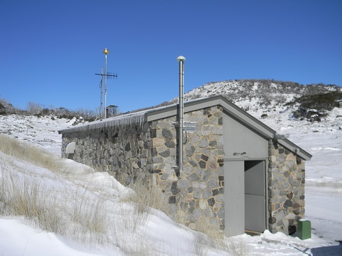
The CORSnet-NSW station at Perisher Valley.
Importantly, AUSPOS performs true simultaneous multi-baseline processing, i.e. it combines GPS baseline processing of data collected at several sites in the same time window (which is therefore correlated) with a 3D least squares network adjustment. Commercial off-the-shelf software routinely used by industry and government only mimics this ideal, requiring a 2-step process of single-baseline processing followed by a 3D network adjustment.
Even if you only submit one RINEX file, AUSPOS still performs simultaneous multi-baseline processing because it uses data from up to 15 CORS. This is often overlooked by novice users who focus on AUSPOS delivering 3D coordinates, which may appear like a ‘fancy’ point position to the uninitiated. However, there is a lot going on under the bonnet.
AUSPOS calculates PU based on the East, North and ellipsoidal height coordinate uncertainties according to the Guideline for Adjustment and Evaluation of Survey Control, which is part of ICSM’s Standard for the Australian Survey Control Network (SP1). The coordinate uncertainties of the East, North and ellipsoidal height components are scaled using an empirically derived model, which is a function of duration, data quality and geographical location (latitude and CORS density), and expressed at the 95% confidence level.
Cluster processing
Simply put, AUSPOS data can be submitted and processed either individually (mark by mark) or collectively (in sessions, like it was observed in the field). AUSPOS accepts submissions of up to 20 RINEX files in one job, which are then processed together as a cluster, using an observation window between the earliest start time and the latest end time.
Cluster processing considers that the multiple data files were collected during the same time window and are therefore correlated. This means that, rather than individually connecting each user site to the surrounding CORS network, processing includes baselines between the user sites, which provides a stronger local connection.
AUSPOS first detects which rover observed the longest, and this becomes the hub for the user data. Basically, the position of the hub is determined relative to the surrounding CORS, and then all other rovers are processed relative to the hub (provided there is sufficient data overlap of at least 1 hour). Importantly, this places increased emphasis on local relativity between survey marks.
If the survey is planned accordingly, the user site with the longest dataset acts as a hub connecting to all other user sites. If the data overlap of a particular user site with respect to the hub (or another user site) is too short, AUSPOS attempts to compute a baseline to a CORS instead (a strategy based on the maximum number of single-difference observations is used to form the baselines computed in the cluster), thereby losing the desired local connection. If its data quality is insufficient, the user site may be deleted from the cluster.
In theory, and if the survey is planned appropriately, the AUSPOS cluster should therefore provide a stronger connection between the user sites compared to processing each dataset individually. The savvy reader is encouraged to think about the permutations and combinations of network design and potential advantages of clustering.
AUSPOS for datum modernisation
DCS Spatial Services, a unit of the NSW Department of Customer Service (DCS), is responsible for the maintenance of the NSW survey control network. With all CORSnet-NSW stations contributing to the AUSPOS service, it delivers high-quality positioning results even for shorter observation sessions of at least 2 hours across NSW, provided sky view conditions are reasonable.
Consequently, in some situations, the use of AUSPOS campaigns has developed into a capable and reliable alternative to conducting traditional static GNSS baseline surveys. AUSPOS also forms a fundamental component of vertical datum modernisation and the propagation of the Australian Vertical Working Surface (AVWS).
While traditional GNSS baseline surveys continue to be performed and adjusted by DCS Spatial Services, it also applies, expands and accelerates the use of AUSPOS. Datasets of at least 6 hours duration propagate the datum in NSW via the National GNSS Campaign Archive (NGCA) hosted by Geoscience Australia, while datasets of less than 6 hours duration strengthen the datum via the state’s Jurisdictional Data Archive (JDA).
To date, more than 12,000 AUSPOS solutions have been used to help maintain and improve the NSW survey control network. These are then expressed as baselines to nearby CORS for inclusion in the GDA2020 national and state adjustments.
To allow NSW users to reap the benefits of AUSPOS processing in a timely manner, DCS Spatial Services has developed and implemented a monthly workflow to automate, as much as possible, the update of survey mark coordinates, heights and their uncertainties in SCIMS based on AUSPOS data. The immediate purpose is to upgrade unestablished marks to established, attach a PU to the coordinates and quicky make them available on public record, until these initial values are updated via the GDA2020 state adjustment (six-monthly).
During the two years since June 2020, more than 3,600 SCIMS updates for more than 1,800 marks have been undertaken via this monthly workflow, providing a quicker way to deliver more accurate information to our customers as we continue to upgrade the state’s survey control network.
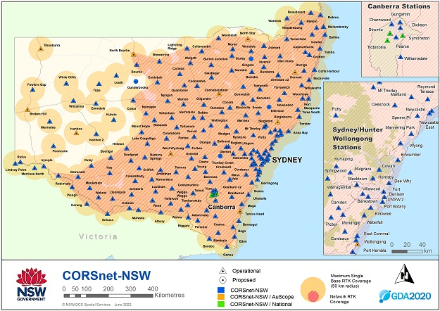
The CORSnet-NSW network reaches across the whole state.
Before AUSPOS datasets are individually processed by DCS Spatial Services, they are subject to a quality assurance process, which ensures a minimum observation session length of 2 hours, certainty about antenna type and antenna height, and involves RINEX file screening and editing to ensure correct header information and sufficient data quality. The AUSPOS results then go through a quality check to assess whether the solution is reliable and suitable for SCIMS update.
Using AUSPOS to support our datum modernisation efforts has several advantages. The field work is quick, logistically simple and very efficient, with reliable solutions achieved even under challenging sky view conditions (particularly for sessions exceeding 6 hours duration).
AUSPOS processing is consistent, of the highest possible standard and very time-efficient, providing a direct connection to the datum (CORS) via a sophisticated, scientific software package using the best products and models available at the time.
The processing results can be ingested by the GDA2020 state adjustment in an automated fashion with minimal effort. Rather than archiving the results, the data is archived and able to be reprocessed at any time to investigate issues or take advantage of improved modelling.
It is recognised that AUSPOS represents an absolute positioning technique because it connects to the surrounding CORS rather than adjacent ground marks. However, the NSW survey control network is becoming so tight that one can anticipate there will soon be little difference between relative and absolute positioning.
The profession is encouraged to contribute to maintaining, expanding and improving the NSW survey control network by submitting suitable, industry-observed AUSPOS datasets and related metadata to DCS Spatial Services.
These AUSPOS data submissions must include:
- RINEX observation file of at least 2 hours duration. Including the raw binary file in the manufacturer’s native format is optional but strongly recommended.
- Completed log sheet or field notes, clearly indicating observation date/time, mark observed, receiver and antenna type and serial number, and antenna height measured vertically to the ARP.
- AUSPOS processing report.
- Locality Sketch Plan for any new mark placed (submitted separately to the AUSPOS data).
- Photographs of the mark, indicating mark type and sky view conditions (optional but recommended).
For clarity and ease of operation, we recommend using the generic DCS Spatial Services GNSS log sheet, available as part of the resource pack for Surveyor-General’s Direction No. 12. The Excel version of the log sheet can easily be modified to accommodate individual needs (e.g. inserting equipment details), which makes it very efficient when printed for use in the field or converted to pdf format.
If the antenna height is routinely measured using a height hook or slant measurement, the relevant antenna diagram and offset calculations to convert this value to the ARP can be included as an image (generally sourced from the equipment manual).
In this regard, a little preparation provides great benefits in the field and further downstream. We found this very valuable when revisiting log sheets from many years ago to mine data for purposes that were not envisaged when the data was originally collected.
Conclusion
The use of AUSPOS campaigns has developed into a capable and reliable alternative or addition to conducting traditional static GNSS baseline surveys in some situations, particularly in NSW with all CORSnet-NSW stations contributing to the AUSPOS service. AUSPOS can deliver high-quality positioning results even for shorter observation sessions of at least 2 hours across the state, provided sky view conditions are reasonable.
This article has looked under the AUSPOS bonnet and explained how AUSPOS solutions are used to help maintain and improve the NSW survey control network. We have also outlined the requirements for industry-observed AUSPOS datasets to be submitted to DCS Spatial Services for potential update of SCIMS and inclusion in the GDA2020 state adjustment. An upcoming article will focus on practical tips and tricks for AUSPOS users.
Dr Volker Janssen and Simon McElroy work at DCS Spatial Services, a unit of the NSW Department of Customer Service.
This article was first published in the Oct/Nov 2022 issue of Position magazine.
Stay up to date by getting stories like this delivered to your inbox.
Sign up to receive our free weekly Spatial Source newsletter.


