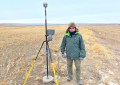
Topcon’s new FC-5000 is built as tough as they come: with industry-leading IP-68 and MIL-STD-810G certification, this rugged Windows tablet can withstand water, humidity, sand, dust, vibration, shock and extreme temperatures.
Powered by Windows 10 and with a large, sunlight-readable display, Topcon’s FC-5000 is your office, anywhere. The capacitive touch screen has finger, glove, small tip stylus and water options and is optically bonded to increase visibility in a wide range of conditions.

The FC-5000 is compatible with all Topcon survey solutions, including total stations, GNSS and MAGNET Field, Site and Layout software.
Complete with two built-in cameras – an eight megapixel camera with autofocus and LED flash for field photography, plus a two megapixel camera on the front for video meetings, the FC-5000 is all you need in the field. It also comes with 64GB of flash storage so users can keep a large number of files within the unit.
With a 4G modem, internal GNSS navigation as standard, LongLink Bluetooth connectivity and Wi-Fi as standard, Topcon’s FC-5000 is fully specked for maximum convenience and on-site productivity. With an impressive 15 hours’ battery life, it will go the distance and keep up with the demands of the job.

For more information about Topcon’s FC-5000 call Australian distributor Position Partners on 1300 867 266, visit www.positionpartners.com.au or email info@positionpartners.com.au.