By Kitty McCarthy
A proof-of-concept trial of Before You Dig Australia’s (BYDA) Digital Utility Portal (BDUP) has tested whether diverse underground utility data be visualised coherently on a single GIS platform.
Australia records more than 20,000 underground utility strikes per year, with annual indirect and social costs estimated at $4.6 billion.
Crucially, much of this risk arises long before excavation begins. Surveyors, designers and engineers often work from a patchwork of PDF plans, issued by dozens of asset owners, repeatedly re-digitised and redrawn.
These static documents must be manually pieced together to create a picture of the subsurface environment — a fragmented approach that introduces uncertainty at the very moment when safety-critical decisions are being made.
Every reinterpretation consumes scarce engineering time, introduces potential errors and increases project risk.
The status quo
For four decades, BYDA has operated the national service for underground utility location data, helping to minimise utility strikes and enable safer excavation practices.
Understanding what lies beneath the surface is no longer just a safety requirement — it is central to project efficiency, cost management and national productivity.
Yet despite the critical nature of this work, the mechanisms for accessing this information have remained largely static.
Internationally, digital solutions for underground asset coordination are becoming standard.
The National Underground Asset Register in the UK, KLIC in the Netherlands, and Hong Kong’s UUIS have demonstrated that centralised, digital access to underground utility data can reduce project delays, enhance safety and improve coordination across sectors.
Australia has lagged behind this trend, so the BDUP represents a first attempt to test a national digital approach in a local context, addressing both the technical and behavioural challenges inherent in digital adoption.
Proof of concept
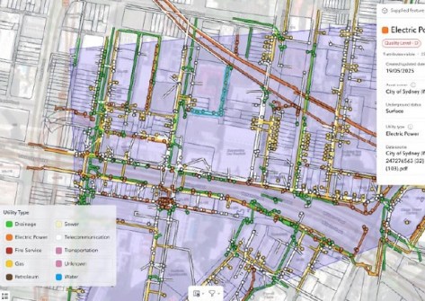
Developed and tested at scale in 2025, BDUP leverages modern geospatial technology to deliver utility information digitally, allowing for coherent mapping, advanced spatial querying, and more reliable decision-making.
The proof-of-concept (PoC) began in late 2024 with Reveal as technology partner, supported by more than 1,000 industry stakeholders through surveys, interviews, webinars and testing.
Asset owners such as Telstra, NBN Co, Ausgrid, Jemena Gas, and Endeavour Energy contributed or committed data, enabling the PoC to scale from a 10-hectare prototype in Woolloomooloo to a 100,000-hectare test environment across Greater Sydney.
The goal was feasibility rather than perfection. The PoC sought to answer critical questions:
- Could diverse underground utility data be visualised coherently on a single GIS platform?
- Could the system meet strict security and SOCI (Security of Critical Infrastructure) requirements?
- Would users and asset owners trust the platform enough to engage meaningfully?
- Would digital access improve safety and workflow efficiency?
Key findings
Across interviews and surveys, safety emerged as the strongest value proposition. Consolidated, digital access reduces the risk of misinterpretation and supports more robust risk assessment at the design stage.
BYDA’s 2024 economic study estimated that digital access through BDUP could reduce utility strikes by 17%, a significant improvement in safety outcomes.
The PoC also highlighted substantial productivity gains. Designers reported saving an average of 9.6 hours per planning request, largely through reduced re-digitisation and earlier design starts. Construction teams reported even greater savings at 18.3 hours per request.
A live case showed that referral response time dropped from 180 minutes to 15 seconds, and collated plan preparation reduced from 15 minutes to 3 minutes.

The PoC highlighted the complexity of building a national shared system:
- Data came in varied formats and resolutions;
- Data readiness ranged from fully digital to PDF-only;
- User needs varied: engineers required metadata, offsets, and quality levels; construction teams sought parcel layers and clearer spatial context; asset owners focused on access control, cyber assurance, and clarity around data use.
Balancing these requirements while meeting strict SOCI obligations shaped the early BDUP architecture, demonstrating that secure, trusted, and interoperable digital coordination is achievable.
Trust was also a key factor. Some asset owners participated immediately, while others required clearer guidance. These discussions reinforced that a national digital platform is feasible with strong frameworks and cooperative engagement.
Who needs BDUP?
BDUP is designed for safety by design, targeting the planning and design stage where risks are locked in and PDF workflow inefficiencies are highest. Likely early adopters include:
- Engineering and design consultants;
- Construction delivery teams;
- Local government planners;
- Utilities conducting network co-ordination; and
- Universities training future engineers.
As mobile capability matures, BDUP’s utility will extend to field crews, locators, and verification activities, providing end-to-end geospatial utility awareness.
Scaling the PoC results nationally, BDUP could save 5.2 million hours of engineering time per year — equivalent to 2,750 full-time positions or roughly $330 million in wages.
What happens next?
With the PoC complete, BYDA is advancing to a multi-state pilot in 2026, collaborating with asset owners, major projects, and state governments. Candidate regions include Western Australia, Greater Sydney and Brisbane 2032 Olympic precincts.
Pilot priorities include:
- Integrating overhead assets into the map
- Onboarding hundreds of new users across asset owners, design, construction and local government to trial the platform in real project workflows.
- Conducting case studies to quantify safety and efficiency gains
- Testing pricing and commercial models within BYDA’s not-for-profit framework
- Ingesting as-builts contributed by users to improve strengthen data accuracy and begin creating a continually improving national dataset.
The BDUP proof-of-concept does not claim to resolve all challenges in data coordination or digital transformation. However, it provides a credible, evidence-based foundation.

The PoC confirmed what the geospatial and engineering communities have long recognised: structured, accessible, and consistent utility information underpins safety, productivity, and informed decision-making.
As the 2026 pilot approaches, focus is shifting from proving concept to proving implementation.
BYDA invites collaboration from asset owners, governments, and industry partners as Australia charts the next steps toward a national digital utility data platform — one that promises safer worksites, more efficient projects, and a stronger geospatial ecosystem.
Kitty McCarthy is Economic Research Advisor with Before You Dig Australia. Contact kitty.mccarthy@byda.com.au.
Resources:
BYDA Digital Utility Portal – Showcase
Boosting Productivity Strengthening Safety: The BYDA Digital Utility Portal
BYDA Digital Utility Portal PoC Findings Report
BYDA Portal | BYDA Digital Utility Portal – Member Partnership Hub