Selected tide gauge stations across Western Australia are having their vertical reference datum updated.
The Western Australia Department of Transport and Major Infrastructure (DTMI) has announced that it is updating the datum from Chart Datum (CD) to Lowest Astronomical Tide (LAT).
The change applies to tide gauges at these locations:
- Bremer Bay
- Busselton – Port Geographe
- Caddadup
- Cape Bouvard
- Harvey Estuary
- Jurien Bay
- Mandurah
- Peel Inlet
- Two Rocks
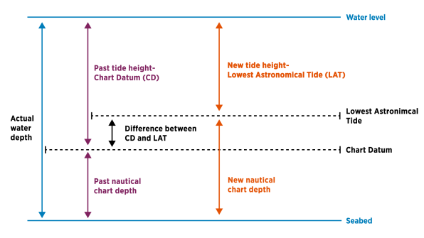
According to the DTMI, users might notice that reported tidal levels and predictions seem lower than they did previously.
The Department points out that “the total measurement from the water’s surface to the seabed is not changing. Only the tide gauge ‘zero point’ is being updated. As a result, tide heights will appear lower, while charted water depths will appear higher.”
The update brings DTMI’s tidal datums into alignment with those used by the Bureau of Meteorology and the Australian Hydrographic Office.