

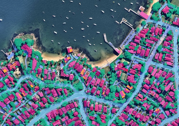
Fifth and latest generation of Nearmap AI, showing Watsons Bay, NSW.
PARTNER FEATURE
By Dan Paul, General Manager ANZ, Nearmap
Rapid advancements in artificial intelligence, deep-learning and analysis-ready data are ushering in a fourth era of geospatial data and analysis.
The scaling of geospatial artificial intelligence makes it possible to transition from analysis-ready data to application-ready information. This new era will enable an easier, more flexible way to integrate geospatial artificial intelligence data directly into enterprise applications.
This is a game changer. It will transform how we access and use data on objects, events, or other location features that describe our ever-changing world.
A walk down memory lane
At the dawn of digital mapping, location information and maps first became available on mainframe computers. Satellites increased the scale and reach of data captures.
The World Wide Web, search engines, big data and the scaling of personal computing were some key milestones in the second era of geospatial data. This was the era of MapQuest, the first commercial web-mapping application, and the start of the democratisation of geospatial data.
The sector then took a huge leap further during the renaissance of artificial intelligence, in the third era. Deep learning and machine learning enabled organisations to systemically create location datasets and geospatial artificial intelligence. This would eventually enable the creation of AI-derived data products.
Responding to a changing climate with smarter intelligence
The fourth era of geospatial data could not have arrived at a better time, as the world grapples with the challenges of a changing climate. This era provides web-scale computing and storage, new artificial intelligence techniques and high-resolution capture systems. This enables the rapid and consistent creation of nation-wide property level information, ready for use in enterprise applications.
We only need to look at the past year for evidence of this. For the third consecutive time, Australia is in the grips of La Niña, spelling more devastation ahead for many Australians.
When it’s not pouring, parts of Australia are battling bushfires and drought, including the unprecedented 2019–20 ‘Black Summer’ bushfires that burned through more than 10 million hectares of land in southern parts of the country.
Never before has Australia and the world needed powerful data, insights and tools as much as it does now to rapidly evaluate, manage and respond to environmental and property risks.
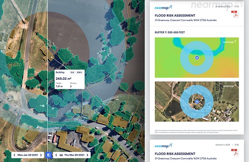
A prototype of the Assessment Report for automated Nearmap Flood Risk Assessments, showing Cornwallis, NSW.
Tapping into hyper-local data
Fortunately, today’s modern aerial imaging technology offers far more than just a bird’s-eye view.
These days, governments and organisations can access a suite of smart technologies including regularly updated high-resolution aerial imagery, explorable 3D data, and automated, AI-powered analytics that provide rich layers of invaluable information and insights.
In other words, modern location intelligence and aerial imagery — produced by companies including home-grown Australian technology company, Nearmap — can give organisations in sectors including insurance, government, financial services, architecture, construction and engineering, another powerful type of data to make better informed decisions.
Next phase of property risk management
With the latest generation of Nearmap AI, application-ready information is created by a new deep-learning model trained on a much larger data set. This includes over a million labelled images.
This machine learning capability now acts as a powerful platform on which a suite of AI-products will be developed. This starts with one of the most accurate AI-enabled property risk management capabilities in the market.
This includes giving organisations access to automated roof condition assessments, fire risk assessment and flood risk assessments. Nearmap is also applying machine-learning analysis to our capture of weather catastrophes and natural disasters, providing even more rapid insights to aid response and recovery efforts.
This latest version of Nearmap AI also includes performance enhancements to existing layers, access to 78 layers of automated mapping, and five new AI packs that bundle the AI layers into products for different use cases, including identifying objects on roofs or debris.
15 years of building the most intelligent map on Earth
Nearmap is the only company in its field that owns the entire technology stack for location analytics, including camera technology, image processing, data and content, delivery and machine learning capability. With Nearmap technology and mapping, organisations can access a reliable and trusted end-to-end solution for location analytics and aerial imagery to help them better predict, prepare, respond and recover from the evolving challenges of a changing climate.
Access to rich data will inherently become more important as our globe and weather patterns change. Equipping organisations with world-leading machine-learning intelligence and giving them access to an extensive library of historical and current location data, will undoubtedly transform the management of environmental and property risks where we’ll see decisions made in almost real-time.
Having all this information on hand opens some wonderful opportunities to contribute to science and our collective understanding of how we live as a nation. Even better, we can effectively jump in a time machine and rerun this analysis on our back catalogue of imagery, with the potential for multi-time analysis in future. This delivers powerful and enlightening information, accessible at any time from a desktop, worldwide.
Nearmap has come a long way since starting 15 years ago in Perth, WA. We’re proud to be celebrating this milestone while congratulating and cheering on fellow Australian-founded technology and innovation firms, punching well above their weight in a globally competitive sector. Some of these firms, including Nearmap, recently featured on the ‘2022 AFR BOSS Most Innovative Companies’ ranking.
Our team at Nearmap loves connecting with innovative organisations, and working together to help grow your business, and solve your biggest challenges. And with the latest Nearmap data, insights, and tools, you too can be at the forefront of the fourth era of geospatial data.
Dan Paull is General Manager of Australia and New Zealand at Nearmap, a location intelligence company with operations in Australia, New Zealand, the USA and Canada. The company provides organisations with instant access to high resolution aerial imagery, city-scale 3D content, artificial intelligence data sets, and geospatial tools.
Learn more about the newest aerial technology solutions at nearmap.com.


