

Image © iStockphoto/FrankRamspott
The Australian Height Datum is beginning to show its age, so is it time for a new approach?
By Dr Volker Janssen and Simon McElroy
The Australian Height Datum (AHD) celebrates its 50th anniversary this year and it remains Australia’s first and only legal vertical datum. This article is the second in a series celebrating the AHD’s golden jubilee, with a focus on NSW.
In the first article, we outlined the history, achievements and longevity of the AHD, while also noting its shortcomings. This article looks ahead to a new era of vertical datum determination, based on GNSS and airborne gravity, culminating in the Australian Vertical Working Surface (AVWS).
The shortcomings of the AHD
The era of GNSS technology ushered in the development of geoid or quasigeoid models to convert GNSS-derived ellipsoidal heights to physical heights, including the AUSGeoid models for Australia. This conversion is often needed because positions obtained by GNSS include heights referred to a reference ellipsoid.
These heights are based purely on the geometry of the ellipsoid and therefore have no physical meaning. They cannot be used to predict the direction of fluid flow because they do not consider changes in gravitational potential. In practice, however, heights are generally required that correctly reflect the flow of fluids, for example in drainage and pipeline design.
Addressing the shortcomings of the AHD in an era of ever-increasing usage and availability of GNSS and airborne gravity measurements, options for a potential new vertical datum were investigated at the national level. This culminated in the development of the Australian Vertical Working Surface (AVWS) as an alternative for users requiring higher-quality physical heights than those the AHD can provide. The AVWS enables early adopters to realise the full potential of modern technology, making height determination and transfer more efficient than with the traditional techniques employed in the 1970s and 1980s.
Several countries have used, or are about to use, (nationwide) airborne gravity measurements to develop high-quality gravimetric quasigeoid models to modernise their national vertical datums. For example, this includes the Canadian Geodetic Vertical Datum 2013 (CGVD2013), the New Zealand Vertical Datum 2016 (NZVD2016) and the North American-Pacific Geopotential Datum 2022 (NAPGD2022).
The reasons for moving to vertical datums based on gravimetric quasigeoids can be summarised as follows: The maintenance of national levelling networks is no longer viable (too costly, too time consuming), and the results are too short-lived in countries subject to significant surface displacement.
Gravimetric quasigeoid models are far more cost effective to maintain and less susceptible to surface movements. Their complete spatial coverage provides significant efficiency gains for industry when accessing the datum because propagating height from the nearest levelled benchmark(s) is no longer required. Basically, the datum is available everywhere, so there are no more black holes as in the AHD.
However, digital levelling is still considered the most accurate technique for height transfer across short distances and will retain relevance in surveying for height-critical, local-scale projects. Since a model can only ever be as good as the data that informs it, the systematic acquisition of nationwide airborne gravity has proven to significantly benefit these quasigeoid models.
In Australia, efforts are underway to collect airborne gravity data over targeted regions, including in South Australia and Victoria (Figure 1), to improve the Australian gravimetric quasigeoid model. In Victoria, such airborne gravity surveys have already been successfully completed across coastal Gippsland (2011), south-west Victoria (2019) and near Bendigo (2004 and 2019).
DCS Spatial Services, a business unit of the NSW Department of Customer Service (DCS), is responsible for the maintenance of the NSW survey control network. It is currently preparing a business case for the modernisation of the Foundation Spatial Data Framework (FSDF), which includes an option to secure funding for airborne gravity surveys across the entire state.
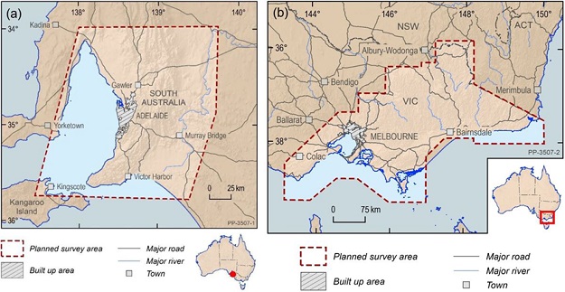
Figure 1: Targeted airborne gravity survey areas in (a) South Australia and (b) Victoria (courtesy of the South Australian and Victorian governments).
New airborne gravity data will significantly improve the gravity (and gravimetric quasigeoid) model and thus the accuracy of GNSS-derived physical heights. It will also be used by geoscientists to further their understanding of Australia’s geological architecture and how it has evolved over time, as well as advance the geoscience that assists management of earth resources, infrastructure and natural hazards.
The Australian Vertical Working Surface
The AVWS is a new reference surface for physical heights in Australia, released on 1 January 2020. It provides an alternative for users requiring higher-quality physical heights (current accuracy about 4–8 cm) than those the AHD can provide (accuracy about 6–13 cm).
GNSS users can access the AVWS by applying the Australian Gravimetric Quasigeoid (AGQG) to their GDA2020 ellipsoidal heights, just like AUSGeoid2020 is used to obtain AHD heights (Figure 2). In practice, this means simply picking AGQG rather than AUSGeoid2020 as the geoid model in your GNSS rover or post-processing software.
The initial version, AGQG_2017, is the gravimetric component of AUSGeoid2020, providing the offset between the ellipsoid and the quasigeoid without being contaminated by the distortions inherent in the AHD. The current version of AGQG (AGQG_20201120) differs from AUSGeoid2020 by between -1.8 m and +0.7 m across Australia, resulting in AVWS (normal) heights differing from AHD (normal-orthometric) heights by the same amount when determined via GNSS and the respective models.
In NSW, users can expect differences of between -0.5 m and +0.1 m (Figure 3). Geoscience Australia is working with all jurisdictions to continuously improve AGQG as new gravity data (particularly airborne gravity) is included and modelling techniques are refined.
Recently, a FrontierSI project (Next Generation Height Reference Frame) investigated current and future user requirements for physical height determination and transfer in Australia. It found that the AHD is still deemed fit for purpose over short distances (less than about 10 km) for applications such as cadastral surveying, civil engineering, construction and mining.
However, users working over larger areas wanted access to higher-quality heights to reap the full benefits of modern technology for environmental studies (including flood or storm modelling), LiDAR surveys, geodesy or hydrography projects.
The study recommended a two-frame approach for heights, with the AHD remaining as Australia’s legal datum and the AVWS being provided as an alternative, analogous with the two-frame approach taken with GDA2020 and ATRF2014. In practice, the surveyor and client would choose which one to use for a particular job, considering relevant legislation that may apply.
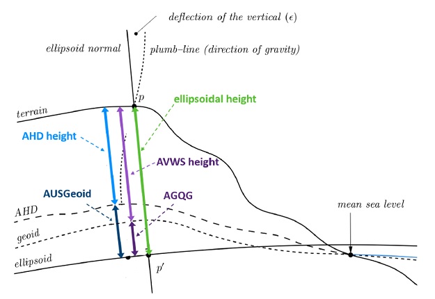
Figure 2: Converting ellipsoidal heights (green) to AHD heights (light blue) by subtracting the AUSGeoid model (dark blue) and to AVWS heights (light purple) by subtracting the AGQG model (dark purple), taken from ICSM’s AVWS technical implementation plan.
From a user perspective, the AVWS provides improved access to physical heights, higher accuracy, increased efficiency, a surface without the known errors of the levelling network, better alignment with GNSS, and national consistency including a seamless onshore-offshore transition.
Given that AVWS heights are not (currently) provided for benchmarks on public record in NSW, these AVWS heights can then be used as reference heights or starting points for spirit levelling surveys. While normal corrections should theoretically be applied to levelled height differences, this can generally be neglected in practice at the cost of introducing a small amount (sub-mm) of error.
Multiple height reference surfaces have been used in Australia for a long time to cater for certain applications, for example the Lowest Astronomical Tide (LAT) used for hydrographic applications. The introduction of the AVWS simply adds to the spatial professional’s toolbox but also highlights the importance of metadata clearly specifying which datum or reference surface you are working in.
The future of the AHD
P.H. Blume, a surveyor with the NSW Maritime Services Board, noted nearly half a century ago: “With the adoption in New South Wales of the Australian Height Datum (AHD) 1971 as a new levelling datum, the previously used Standard Datum has been superseded. The small difference between the two datums has resulted in many surveyors being vocally critical of the new datum and the opinion has been expressed that the introduction of AHD was an unwarranted alteration to a long established and acceptable system.”
He continued: “Further investigation in connection with AHD is certain to continue and as a result of such research into tides, levelling, mathematical adjustments and revision, new values and possibly datums will arise. Because of the ever-changing level of the sea, any new datum would not necessarily agree with AHD, just as AHD did not agree with Standard Datum, which in turn did not agree with former datums based on sea levels. However, the need to replace AHD will doubtless require deep consideration in order to produce very strong and compelling reasons.”
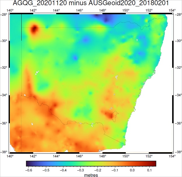
Figure 3: Differences in N values between AGQG_20201120 and AUSGeoid2020 across NSW, which is equivalent to the differences between GNSS-derived AVWS heights and AHD heights.
These sentiments from 1975 are just as true today, and Blume’s crystal-ball wisdom about the debate the profession will soon begin in regard to the AHD and the AVWS is visionary. A testimony to its true quality and immense expense, the AHD has long outlasted its horizontal datum counterparts (AGD66, AGD84, GDA94), and it is unlikely that GDA2020 will still be operating in another 50 years. Acknowledging that there can be only one legal vertical datum, it remains to be seen what the future holds for legal heights in NSW and Australia.
DCS Spatial Services does not expressly advocate or legislate adoption of the AVWS in NSW at this time (currently it is neither implemented nor supported in the state’s survey control database, SCIMS). However, we are collecting and maintaining new ellipsoidal height datasets with the aim to investigate and contribute to future applications of the AVWS.
Conclusion
The AHD remains Australia’s first and only legal vertical datum and is still deemed fit for purpose for most applications. It has been the only vertical datum for most spatial professionals during their entire careers. That some should raise an eyebrow at even the thought of changing it, is quite understandable. But it is, like some of us, showing its age and deteriorating, despite the best efforts to maintain it.
As the sun has set on the age of long level runs across towns, cities, shires, states and the nation, users want physical heights delivered at the push of a button, anywhere and anytime. Positioning tools and sensors now collect data over larger and larger swaths, at increased precisions, and local distortions or warts in the fundamental datum can no longer be tolerated.
There can be only one legal vertical datum, and currently there is no planned push to replace the AHD. DCS Spatial Services has yet to implement the AVWS but continues to investigate and contribute towards it. The successful uptake of any alternative height surface(s), such as the AVWS, will be decided by its users and their clients. You will soon play a key role in deciding the future of the AHD and whether it will be able to celebrate its 75th or maybe even its 100th anniversary.
Helping us celebrate AHD’s golden jubilee, we have discussed the dawning new era of vertical datum determination. The third and final article in the series (to be published in Issue 115, Oct/Nov 2021, of Position magazine) will outline the datum maintenance and modernisation efforts undertaken in NSW through our ongoing Saving AHD projects.
Dr Volker Janssen and Simon McElroy work at DCS Spatial Services, a unit of the NSW Department of Customer Service.
This article was first published in Issue 114 (Aug/Sep 2021) of Position magazine.
Stay up to date by getting stories like this delivered to your inbox.
Sign up to receive our free weekly Spatial Source newsletter.


