

Geospatial research and analysis are critical in providing the evidence base required for policy and planning.
By Scott Limbrick
With Australia facing challenges such as responding to climate change, facilitating energy transitions and delivering adequate housing and infrastructure for cities and regions undergoing demographic shifts, it’s critical that policy and planning decisions are informed by relevant research and analysis.
With the wide variety of factors impacting these environmental, social and economic changes, access to data is vital — though it is not always easy to obtain or use. The cost to researchers, both financial and in terms of time, of obtaining and cleaning geospatial data from different sources can be significant, even as such data is required for detailed analysis. This is why AURIN, the Australian Urban Research Infrastructure Network, seeks to support both researchers and decision-makers by providing access to spatial tools and hard-to-get datasets.
Using these, researchers across Australia have produced work addressing liveability, informing climate change adaption, deepening our understanding of the employment implications of COVID and more. At AURIN we’re always excited to see the range of research only possible with geospatial data, particularly as these findings provide the foundation for government and industry decisions.
Below are just a few examples of the ways researchers have used this data in their work.
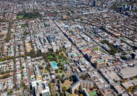
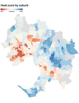
Urban heat islands in Melbourne
As part of the ‘Map of the Month’ initiative — a science communications project led by the University of Melbourne, in collaboration with AURIN, Melbourne Centre for Cities, Melbourne Data Analytics Platform, and Pursuit — academics, community leaders and government representatives have contributed to the development of data-driven maps intended to spark important policy discussions.
One such map, based on research by Dr Thami Croeser and Dr Michele Acuto and produced by Amanda Belton, Dr Emily Fitzgerald and Dr Stuart Lee, using data provided by AURIN and Geoscape Australia, calculated the extent of asphalt and concrete surrounding each building in metropolitan Melbourne. They found that such buildings are surrounded by a total of 271 square kilometres of asphalt and concrete, with more than 50% of all buildings surrounded by land at least one-third concrete and asphalt — and that there is a large east-west divide, with western suburbs exposed to far more heat than those in the east.
This analysis, made possible only with specific data, highlights the problem of a socioeconomic gap in urban heating effects, and points to the need to address this inequality through de-paving certain regions.
The Map of the Month project has been made possible through the support of the Lord Mayor’s Charitable Foundation and partnerships with the Victorian Office for Suburban Development and the Municipal Association of Victoria.
Neighbourhood design and cycling activity
Using cycling infrastructure data made available through AURIN, in addition to data sourced from Vicroads, the Victorian Government and their own surveys, researchers at Monash University conducted a study of the role of neighbourhood design in cycling activity.
The resulting paper, The role of neighbourhood design in cycling activity during COVID-19: An exploration of the Melbourne experience, by Mahsa Naseri, Dr Alexa Delbosc and Dr Liton Kamruzzaman, assesses how various populations in Melbourne changed their cycling activity during lockdown conditions.
This work involved calculating built environment indicators including residential density, green space area, land-use mix, street connectivity and cycling infrastructure coverage, in addition to determining the length of cycling infrastructure in each neighbourhood by applying GIS methods to data from Vicroads and AURIN.
Among other observations, the study found that even during lockdown, significant gaps remained in cycling levels — changed conditions and reduced local traffic did not encourage older people or women to take up cycling at higher rates. With cycling an important opportunity to contribute to health and well-being, these findings provide a valuable resource for planners in ensuring built environments respond to the needs of the wider community. That lockdown conditions made little difference to the uptake of cycling for leisure among these groups indicates that such needs require further research and planning.
Of the importance of data for this research, Mahsa Naseri said, “AURIN data played an important role in this research, offering key insights into Melbourne’s cycling infrastructure. It facilitated a comprehensive analysis, connecting neighbourhood design, demographics, and cycling behaviour during Covid-19 lockdowns, providing valuable input for urban planning and policy decisions.”
Adding built environments to climate models
Using Geoscape Buildings data accessed through AURIN’s Restricted Data program, Dr Mathew Lipson and his UNSW colleagues at the ARC Centre of Excellence for Climate Extremes, Dr Melissa Hart and Dr Negin Nazarian, have worked to create a new set of gridded data that they are able to feed into their models.
Dr Lipson noted the importance of high-resolution, standardised data for their work: “From the data that you’ve provided us, we can calculate parameters describing the city and feed it straight into our climate models. This is rare data that isn’t available in a lot of places – often we’re trying to estimate parameters using satellite data or people going out and doing surveys. So it’s really, really valuable in that sense.”
By better incorporating built characteristics into climate models, it will be possible to understand and simulate climate impacts and mitigation measures — the importance of which has also been highlighted through projects such as the Map of the Month.
Future focus
In addition to work on building the foundation for Australia’s Urban Digital Twins and ensuring continued access to our existing datasets and tools, AURIN is proud to be facilitating wider access to commercial data through several partnerships. As a result of these collaborations, researchers are able to obtain data at a reduced cost from providers including APM, Geoscape and Ambient Maps, and enabling research informed by leading property, spatial and noise data.
We’re also looking forward to providing new, hard-to-get data as part of the Australian Urban Health Indicators (AusUrb-HI) project, in collaboration with PHRN, AUO, QUT and ARDC, which is developing a suite of indicator data assets that will improve our ability to understand the health of Australian urban and regional populations.
Geospatial data and tools continue to support important research and analysis — work which would be incredibly difficult without such resources, but which continues to be critical in providing the evidence base required for effective, responsive policy and planning.
Scott Limbrick is Media Manager at AURIN.


