Welcome to the latest instalment of our new regular feature, Spatial Snippets, in which we bring you a round-up of all the bits and pieces of geospatial news that didn’t make it into our normal daily and weekly coverage.
Here are our snippets for this week:
The NSW Transport Open Data Hub has been updated with a refreshed look and extra functionality. This impressive data repository has more than 47,000 active users and has amassed more than 25 billion API hits!
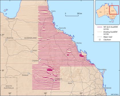
Geoscience Australia has announced that the latest AusAEM airborne electromagnetics (AEM) survey has been completed. The North-East Queensland AusAEM survey encompassed 28,679 line kilometres at 20-kilometre spacing, resulting in a huge chunk of the state being covered. GA says the data will be released in the coming months once quality assurance has been completed.
The Australian Space Agency is working on a potential Australian ‘sustainability of space activities’ policy, and is seeking input from industry, academia and government. The consultation will close on 8 November.
The University of Adelaide has a two-year, Grant-Funded Researcher role going in the field of remote sensing and vegetation ecology using the recently launched, homegrown Kanyini satellite. The successful applicant will take part in two projects (supported by SmartSat CRC and sponsored by the ARC, respectively) and will have the opportunity to conduct field work and collaborate with investigators from TERN and James Cook University.
If you’re in Western Australia, don’t forget that the WA Geospatial Conference and Awards Dinner will take place on Friday, 8th November. It’s not too late to register.
C.R. Kennedy will hold a seminar on 15 November at the Civil Contractors Federation in Adelaide, covering a variety of topics such as manual, semi-automated, automated and total monitoring techniques and technologies. Geospatial Council of Australia (GCA) CPD points will be available.
The University of South Australia is offering a four-week Southern Hemisphere Space Studies Program at its Mawson Lakes campus, commencing mid-January 2025. The course, to be conducted in partnership with the International Space University, will provide a comprehensive understanding of the key activities and areas of knowledge required by today’s space professionals.
If hydrographic surveying is your thing, there are two events coming up that might interest you. The first is a seminar to be held in Mackay, Queensland, on 13 November, jointly organised by the GCA and the Australasian Hydrographic Society. The second is a four-day tides workshop to be held at Flinders Ports in Adelaide, and which will include a fascinating field trip.
Overseas, and the UK Space Agency’s Chief Executive, Dr Paul Bate, has assumed the Chair of the Committee on Earth Observation Satellites (CEOS). He takes over from Éric Laliberté, CEOS Chair for 2024 and Director General of the Canadian Space Agency.
And still in the United Kingdom, and the UK is taking more steps to develop greater resilience in its vital positioning, navigation and timing (PNT) system. It has identified an opportunity to advance some of the actions outlined in the UK National Framework for Greater PNT Resilience via a project focusing on two-way satellite time and frequency transfer, including removing GNSS dependence from a Ministry of Defence eLoran transmitter.
Finally, here are some recent Spatial Source news items you might have missed:
- New report into Queensland’s surveying workforce
- OGC releases new API Maps core standard
- US eases satellite remote sensing export controls
- Seabed mapping of vital global importance
- C.R. Kennedy now distributing the Teledyne Ladybug6
- Bentley, Google partner for geospatial content
- Australia’s Arlula joins Maxar Intelligence’s Partner Ecosystem
- Melbourne subsurface model wins digital award
Do you have a Spatial Snippet to share? Let us know.
And make sure you don’t miss out any geospatial news from across Australia and around the world — subscribe to our free weekly Spatial Source newsletter, sent out every Wednesday morning.


