Our regular Spatial Snippets update brings you a round-up of all the bits and pieces of geospatial news that didn’t make it into our normal daily and weekly coverage.
We start off with news that the Gordon and Betty Moore Foundation has granted the Smithsonian Tropical Research Institute US$12 million to support GEO-TREES, a partnership of a dozen research organisations providing a free, definitive standard for quantification of forest carbon everywhere, in real time. GEO-TREES uses complementary approaches, including ground-based measurement of trees, soil carbon sampling and ground- and air-based LiDAR to collect real-time estimates of carbon storage. Those estimates are used to calibrate satellite measurements and form the foundation for actionable valuation of forest carbon sequestration services.
By combining household survey data with global Earth observation data and geospatial modelling techniques, Swiss scientists and colleagues have created detailed maps of safely managed drinking water services (SMDWS) use across 135 low- and middle-income countries (LMICs), finding that only one in three people in these countries had access to safely managed drinking water in 2020. This leaves an estimated 4.4 billion people in LMICs lacking SMDWS — compared to the estimate of 2 billion people in 2020 given by the World Health Organization and United Nations Children’s Fund Joint Monitoring Programme for Water Supply, Sanitation and Hygiene.
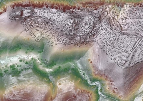
A team of researchers has used drone-based LiDAR to map the archaeological scale and layout of two recently discovered high-elevation medieval city sites in Uzbekistan, making them some of the largest ever documented in the mountainous parts of the Silk Road. The centimetre-level scans enabled computer analysis of the ancient surfaces, providing an unprecedented view of the cities’ architecture and organisation. “These are some of the highest-resolution LiDAR images of archaeological sites ever published,” said one of the team leaders, Michael Frachetti. “They were made possible, in part, because of the unique erosion dynamics in this mountain setting.”
NASA’s EMIT — Earth Surface Mineral Dust Source Investigation — imaging spectrometer, based on the International Space Station, has been given a mission extension. Originally intended to map minerals in desert regions to assess the role of dust on the climate, EMIT was soon pressed into service to also seek out sources of greenhouse gas emissions. Now, the instrument will move beyond looking at deserts to also take in other terrain and contribute to agriculture, hydrology and climate science studies.
The US-based GIS Certification Institute (GISCI) has announced that its Geographic Information Systems Professional (GISP) certification program has received accreditation from the US Council of Engineering and Scientific Specialty Boards. This follows an announcement in August that GISIC had formed a strategic partnership with Pearson VUE, a provider of computer-based testing for certification and licensure exams, to increase the number of GISCI testing centres worldwide from 800 to 4,500. GISCI says that more than 11,000 people from around the globe have earned the GISP credential.
The UK Hydrographic Office has announced that bathymetric survey data suppliers can (and should) now share their bathymetry data with the UKHO via the UKHO Data Upload service (replacing manual H275 forms), enabling the UKHO to process incoming bathymetric data quickly and accurately for use within its ADMIRALTY products and services to support safety of life at sea. The service also enables users to view previously submitted surveys.
Do you have a Spatial Snippet to share? Let us know by sending us an email.
And make sure you don’t miss out any geospatial news from across Australia and around the world — subscribe to our free weekly Spatial Source newsletter, sent out every Wednesday morning.