Our weekly round-up of all the fragments of geospatial news that didn’t make it into our normal daily coverage.
If you have a Spatial Snippet to share with our readers , please send us an email.
We’ll start off this week with a handful of job vacancies we’ve spotted during our trawls around the internet, beginning with three from NSW.
The Geospatial Strategy & Enablement team within the Department of Climate Change, Energy, the Environment and Water has an opening for a Geospatial Coordination Lead. The role involves providing strategic leadership across geospatial governance, standards and collaboration, and working with internal teams and external partners to enable consistent, high-quality and ethical use of spatial data and applications. Applications close on 17 March.
The same team is also on the lookout for a Geospatial Enablement Lead, who will be responsible for the operation and continuous improvement of the Department’s enterprise geospatial platforms, data pipelines and supporting technologies. Applications close on 17 March.
And Spatial Services, a division of the Department of Customer Service, has a vacancy for a Senior Application Developer for the NSW Point service. The role involves being responsible for planning, creating, testing and documenting new and amended application components of NSW Point, which is an API solution for enriching and enabling location data for the NSW Government. Applications close on 19 March.
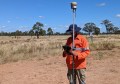
The University of Tasmania is seeking an Associate Professor in Digital Forests for a full-time, four-year, fixed-term role based in Hobart. Based in the School of Geography, Planning and Spatial Sciences, the successful candidate will collaborate with the Australian Forest and Wood Innovations Centre to design and deliver a program using remote sensing, in‑forest sensor networks, machine learning and AI to generate advanced digital forest data and operational insights for the Australian forestry sector.
On the topic of remote sensing, Geoawesome has announced a five-day summit called ‘The Next Geo,’ to be held from 20 to 25 April and open to geospatial professionals and end-users from anywhere in the world. Although it is an online event, it will be supplemented by a series of in-person meet-ups and workshops in various cities around the globe.
Geoscience Australia has announced the return of its distinguished science lectures, mainly aimed at a lay audience, but of interest to many in the geospatial sector. Of particular note will be the Putting the ‘Geo’ into ‘Geospatial’: Shaping the future of Positioning Australia lecture in August, to be presented by Martine Woolf, Ryan Ruddick, Anna Riddell, Lisa Hall and Phil Shears.
During the recent visit to Australia by Canada’s prime minister, Mark Carney, he and our PM Anthony Albanese made a bunch of announcements concerning areas of mutual interest and programs of collaboration. Of interest to Spatial Source readers is that part of it was an intention to build on “the existing MoU between the Canadian Space Agency and the Australian Space Agency, including collaborating on Earth observation missions, which will support bush and wildfire monitoring internationally through satellite imaging and data sharing”.
Survey and Spatial New Zealand’s annual conference will be held from 9 to 11 September 2026, at the Cordis Hotel in Auckland. The theme for this year will be ‘Going to the next level,’ and the organisation says the event will explore how “innovation, strong leadership, cultural understanding, and professional excellence can help continue to strengthen our profession and prepare us for the opportunities and challenges ahead”.
In the USA, the organisers of Geo Week, the huge annual geospatial and mapping event, have announced that for 2027 it will shift venue from Denver, Colorado, to Salt Lake City, Utah. “We’re eager to host Geo Week in Salt Lake City and expand our industry partnerships,” said Lee Corkhill, Event Director. “The city puts our industry’s work on display — from maintaining sophisticated GIS operations covering water systems, utilities, transportation infrastructure, and public lands, to lidar acquisition and open data initiatives — making Salt Lake City an ideal location for showcasing geospatial technology in action.”
Closer to home, the Pacific GIS and Remote Sensing Council has announced that New Zealand-based Locus has become its latest institutional member. Locus specialises in spatial data integration and intelligent workflows using FME and other data platforms.
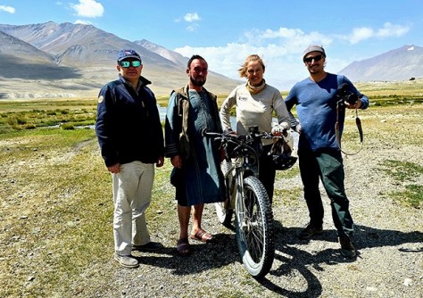
Finally, a team of researchers and explorers, including Australia’s Kate Leeming, have solved a 3,000-year-old mystery about the source of the Oxus River in Afghanistan. Using satellite imagery, maps and on-the-ground perseverance, the team found a previously unknown permanent glacial lake, which feeds into streams that make their way into the Oxus. They have named it Lake Malang after one of their team members, Afghani mountaineer Malang Darya.
Make sure you don’t miss out any geospatial news from across Australia and around the world — subscribe to our free Spatial Source newsletter, sent out every Wednesday and Friday morning.