


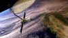
Sentinel-6B is equipped with an improved dual-frequency radar altimeter and microwave radiometer.
Search results for "nasa"

Twin HydroGNSS satellites poised for launch
The satellites will use reflected GNSS signals to monitor Earth’s land- and ice-covered surfaces and oceans.
NISAR’s science phase to begin this month
Early images have revealed the dual-band, NASA-ISRO synthetic aperture radar satellite’s imaging strengths.

Spatial Snippets for Wednesday, 22 October
Enjoy our weekly compilation of general geospatial news snippets from across Australia and around the world.

Satellite data shows NZ’s major cities are sinking
New satellite data shows NZ’s major cities are sinking, mean rising sea levels will affect them sooner.

Australian Earth observations leader receives award
Australian Stuart Minchin has received a lifetime achievement award at the 2025 GEO Awards in Rome.

High school students to get a taste of real research
Students will be offered internships with the IGNIS project, which is mapping heat and lightning across WA.
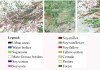
95% accuracy boost in vegetation mapping
A new method more accurately defines areas of natural vegetation and agricultural production by crop type.
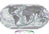
Ocean height data used to map the seafloor below
SWOT satellite data is revealing thousands of seamounts, potentially doubling the number previously known.

OGC appoints Cassie Lee as Chief Innovation Officer
Lee brings wide remote sensing and tech experience to the role, having previously served with NASA and SpaceX.