

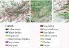
A new method more accurately defines areas of natural vegetation and agricultural production by crop type.
Search results for "NASA"
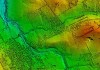
Ocean height data used to map the seafloor below
SWOT satellite data is revealing thousands of seamounts, potentially doubling the number previously known.

OGC appoints Cassie Lee as Chief Innovation Officer
Lee brings wide remote sensing and tech experience to the role, having previously served with NASA and SpaceX.
Mapping to predict lightning strikes and fires
The first round of data collection for the IGNIS Project involved 50 flying hours covering 10,000 km.

18th Australian Space Forum
When:
15 July, 2025 @ 8:30 am – 16 July, 2025 @ 5:00 pm
Where:
Adelaide Convention Centre
The 18th Australian Space Forum will bring together the best and brightest from Australia’s space industry and around the world. The event will feature keynote addresses from local and international space industry leaders and informative[…]
Spatial Snippets for Wednesday, 20 November 2024
Check out our regular weekly compilation of geospatial news snippets from around the world.
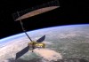
US-India remote sensing satellite closer to launch
The antenna for the NISAR synthetic aperture radar satellite has arrived in India in preparation for launch in 2025.

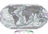
China overtaking the US in space-based EO
China has slightly pulled ahead of the US in a review of commercial space-based remote sensing systems.
Regional geodesy workshops to take place in 2025
The capacity building events will have a focus on Least Developed Countries and Small Island Developing States.

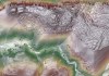
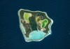
First images from new Earth observation satellites
We’re getting our first look at the capabilities of Europe’s Sentinel-2C and Planet Labs’ Tanager-1 satellites.