

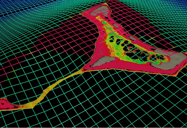
The chart of Suwarrow and Pukupuka in the Cook Islands provides more accurate positioning and wider coverage, including in areas such as shallow lagoons. Courtesy NIWA.
Scientists from New Zealand’s National Institute of Water and Atmospheric Research (NIWA) and Toitū Te Whenua Land Information New Zealand (LINZ) have used satellite technology to chart the Cook Islands’ seafloor in never-before-seen detail.
The work was done as part of Seabed 2030, a collaborative project to produce a definitive map of the world’s ocean floor by 2030.
The chart of Suwarrow and Pukupuka in the Cook Islands builds upon decades-old surveys, with more accurate positioning and wider coverage, including information on harder to reach areas such as shallow lagoons.
Kevin Mackay is a Researcher of Marine Geology at NIWA, and heads the Seabed 2030 South and West Pacific Ocean Data Centre — one of four global Regional Centres, each being responsible for data gathering and mapping in their territory.
Mackay says that using satellites has been a paradigm shift in the way we measure sea floor.
“To measure the depth of the ocean, you would traditionally have to send out a boat with an echosounder, which costs a lot of money and can be dangerous, especially around rough or shallow seas,” he said.
“With satellites, we can access extremely remote locations, with less carbon footprint, and we don’t have to put people in harm’s way.”
The imagery is taken from the World-View-2 and GeoEye-1 satellites
“The technology and processes are really clever – the satellite can see the sea floor in exquisite detail, but to derive the water depth the software needs to get rid of shadows, waves etc,” said Stuart Caie, Manager Hydrographic Survey from LINZ.
“So, it strips away the water and uses complex algorithms to produce depth estimations. It then creates a map with colourings of what the seafloor would look like without any water, which we can then use – it’s really great.”
Seabed 2030 is a collaborative project between The Nippon Foundation and GEBCO. The South and West Pacific Ocean Regional Centre is made up of NIWA, GNS Science and LINZ, who are working together to map over 123 million square kilometres of ocean. Currently, less than 20% of the world’s seafloor is mapped.
Stay up to date by getting stories like this delivered to your inbox.
Sign up to receive our free weekly Spatial Source newsletter.


