

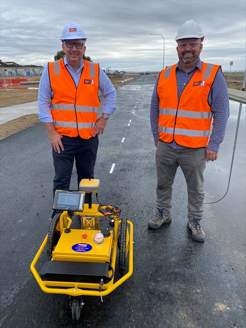
Federal Minister for Resources and Water, Keith Pitt, and Chief Scientist of Geoscience Australia, Dr Steve Hill, with the ‘Tiny Surveyor’ at the Port Wakefield Overpass and Highway Duplication project in South Australia.
The time it takes to complete major road infrastructure projects will be considerably reduced as a result of significant satellite GPS upgrades under a joint Commonwealth, state government and private sector partnership.
The Commonwealth is making a $64 million national investment in upgrading GPS positioning capability, improving accuracy from metres to centimetres.
“Led by Geoscience Australia, the Commonwealth Government will deliver an extra 57 reference stations nationally as part of our 700-plus strong reference station network, partnering with industry and state governments,” said the Federal Minister for Resources and Water, Keith Pitt.
In South Australia for instance, the upgrade will significantly fast track certain works on the Port Wakefield Overpass and Highway Duplication process, with a robot called the ‘Tiny Surveyor’ able to complete line-marking work in days, instead of weeks.
“This technology will improve positioning accuracy from 5 to 10 metres, right down to 3 to 5 centimetres in areas with mobile phone and internet coverage,” said Minister Pitt.
“It will enable government and industry alike to easily connect and access positioning data and pave the way for innovation and new positioning-based products, services and technologies for the benefit of industry and community.”
South Australian Minister for Infrastructure and Transport, Corey Wingard, said the tiny robots will positively impact the $124.5 million Port Wakefield project.
“Gruelling and tedious tasks that would take survey crews weeks to complete manually can be done with this little robot in a matter of days thanks to this ground-breaking technology,” Minister Wingard said.
“It enables survey teams to supervise the robot’s movements in safe location away from heavy machinery and live traffic.”
In South Australia 68 reference stations are involved, including 12 new additions.
South Australia is a good example of the collaborative approach being taken, with more than 40 existing South Australian reference stations operated by industry, including Position Partners and UPG (Ultimate Positioning Group).
Position Partners, which supports construction and geospatial businesses throughout South Australia, has provided the ‘Tiny Surveyor’ for the Port Wakefield project.
“Connected to the reference station network and utilising precise positioning technology, the robot automatically completes even the most complex line-marking projects in a fraction of the time it would take using traditional, manual methods,” said Martin Nix, CEO of Position Partners.
Preliminary works for the expansion and upgrade of the reference station network are advancing, with Geoscience Australia anticipating completion in South Australia by June 2022 and the national project to be completed by June 2023.
Stay up to date by getting stories like this delivered to your inbox.
Sign up to receive our free weekly Spatial Source newsletter.


