.jpg)
A new 3D observation satellite has returned its first images of the Earth.
The German TanDEM-X satellite was launched from
The three-year mission aims to survey the entire 150 million square kilometres of the Earth's land surface.
The newly released images show that the platform is working and ready to team up with the TerraSAR-X satellite that was launched in 2007.
Together, the pair will trace the variation in height across the globe to a precision of better than two metres within six months.
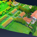
“This will be the first time we will ever have had a globally standardised 3D digital elevation model (DEM) of Earth,” said Alberto Moreira, science director of the mission.
The DEM will be used for commercial, research and security purposes, such as the programming of navigation computers in military jets to enable them to fly at low elevations.
The data could also be used by relief workers after emergencies such as earthquakes, who could use the information to determine the high damage areas following a quake.