

A new method for predicting dust and sandstorms using infrared satellite images has been developed by researchers at the University of Pittsburgh in the US.
The scientists have been able to determine when destructive sandstorms are likely to occur. They used their methods to accurately forecast a large 2008 dust storm in New Mexico, two days in advance, as reported in the Journal of Geophysical Research Earth Surface.
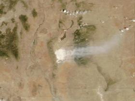
Thermal and visible images of New Mexico's White Sands Dune Field, captured by NASA's Earth-orbiting ASTER (Advanced Spaceborne Thermal Emission and Reflectance Radiometer) instrument, provided a reliable indication of when soil moisture levels were low enough to result in a dust storm.
The researchers plan to build on their work by observing arid and semi-arid areas with different soil characteristics and widen the method to take into account soil density and composition.
The team say this approach could be expanded into a worldwide system to monitor areas prone to dust storms or to track drought in regions threatened by desertification.
The paper is available on the University's Web site.


