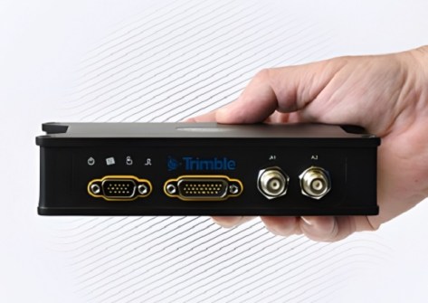
Trimble has introduced two new positioning portfolios for mobile mapping and direct georeferencing — Applanix POS LVX+ and Applanix POS AVX RTX — suitable for land-based and aerial mobile mapping applications.
Both include a one-year subscription to the Trimble CenterPoint RTX correction service and Applanix POSPac Complete (desktop and cloud), which includes post-processed CenterPoint RTX (POSPac PP-RTX).
By integrating real-time and post-processed data, users can achieve global coverage without the need for traditional GNSS base stations. Both systems support Trimble IonoGuard technology for advanced mitigation against ionospheric disruptions.
The POS LVX+ portfolio, available in six models, offers:
- Incorporation of the Applanix IN-Fusion+ multi-sensor-aided inertial engine, which maintains performance in challenging environments such as urban canyons or tree canopies.
- Suitability for projects using LiDAR sensors or cameras, as well as for fleet management and automotive applications.
- Onboard and external IMUs.
- Customised for airborne positioning and orientation.
The Applanix POS AVX RTX portfolio has four variants for mapping at different flying altitudes, and features:
- Over-the-air correction technology that achieves positioning, velocity and orientation accuracy of up to 3 cm horizontal RMS and 6 cm vertical RMS without any additional setup or infrastructure.
- IMUs and an FAA-certified antenna and cabling.
- The combination of real-time and post-processed RTX correction data.