Purchase 50cm Pleiades 1A imagery over Australia or New Zealand and obtain 10 times the coverage in 2.5m SPOTMaps data at no additional cost.
The Pleiades 1A satellite offers 50cm resolution, a 20km swath width and 1 million km2 of daily coverage to ensure best of class acquisition capacity for the commercial market.
The Pleiades 1A satellite offers 50cm resolution, a 20km swath width and 1 million km2 of daily coverage to ensure best of class acquisition capacity for the commercial market.
Pleiades 1A imagery delivers the detail you need over your target areas of interest, while our unique 2.5m resolution off-the-shelf, orthorectified and seamlessly mosaiced SPOTMaps solution, is ideally suited for your broader perspective requirements while still retaining significant detail.
Offer examples:
Example 1: You require 50cm optical imagery over your 240sqkm project area. If you purchase 240sqkm of Pleiades imagery, we will also provide 2,400sqkm of SPOTMaps at no additional charge*.
Example 2: You are planning a new pipeline and have identified three potential corridors where 50cm imagery is essential and synoptic 2.5m imagery is required for a regional perspective. This is possible when you purchase Pleiades imagery along the corridors and receive 10 times the area in SPOTMaps*.
Astrium GEO-Information Services is producing 50cm orthorectified mosaics and speculatively tasking the satellite to acquire large area coverage’s. If you are interested in having wide coverage over your area of interest, contact our customer service team for quotations and tasking requests on Tel: +61 (0)2 6262 9662; Email sales@astrium-geo.com.au or visit us on the Astrium booth at ISPRS 2012 in Melbourne August 25 – 31.
Building on 25 years of successful SPOT satellite operations, Astrium GEO-Information Services is well placed to provide all your satellite imagery requirements, from 50cm to 22m optical solutions and 1m to 16m radar solutions.
* SPOTMaps must completely overlap the same area as the Pleiades area

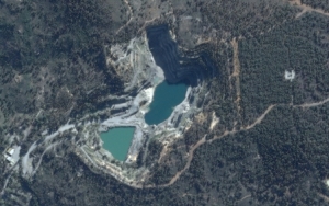
Figure 1: Illustrates 50cm Pleiades 1A imagery over a disused open pit mine, south east of Brigadoon, Western Australia

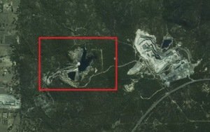
Figure 2: Illustrates our broader perspective 2.5m SPOTMaps solution over the same open pit mine, south east of Brigadoon, Western Australia. The red box illustrates the area covered by Pleiades in Figure 1.

Figure 3: Illustrates 50cm Pleiades 1A imagery over the Novotel Swan Valley Resort in The Vines, Western Australia

Figure 4: Illustrates our broader perspective 2.5m SPOTMaps solution over The Vines region in Western Australia. The red box illustrates the area covered by Pleiades in Figure 3.
![]()
Astrium Geo-Information Services – Australia
23 Torrens Street, Braddon ACT 2612
PO Box 993, Civic Square ACT 2608 Australia
Tel: +61(2) 6262 9662 | Fax: +61(2) 6262 6676


