

The Let’s Locate immersion program aims to help high school students take the next step to learn more about the industry.
By Greg Ledwidge
For decades the surveying and geospatial industry has tried to engage high school students in a variety of ways in the hope of getting them to pursue a career in our industry. Passionate individuals have initiated and progressed a range of engagement activities such as speaking in schools, the Maths in Surveying days and careers expos.
These efforts have had success, but there was always the question of where students could go to learn more. Some may do work experience or seek out further education opportunities. But what happens to those who are curious to learn more but, for a range of reasons, can’t take it further and therefore lose interest? There is a missing link in the system — Let’s Locate looks to bridge that link.
Let’s Locate is an immersion program designed to help interested and curious high school students, and others, take the next step to learn more about our industry. They can get a taste for surveying or geospatial and immerse themselves in the industry in a structured and supportive learning environment. They get the opportunity to learn what a surveyor or geospatial professional does and become more aware of the skills and education needed. In, addition they get to play with some of the great technology we use.
The program runs for up to five days, generally in school holidays — and surely, all parents wish to have their kids doing something productive, fun and safe for a week of the holidays!
At the end of each program the students get to connect with supportive local companies, the vocational training sector and interested universities. There is, of course, follow-up and ongoing connections with industry groups to facilitate work experience — Surveying Careers has been great in making this happen so far.
While the program was previously delivered on a small local scale, it was in 2024 that various peak industry groups came together in the ACT to progress to towards our first modern pilot program. It was great to see representatives from GCA, ISNSW, Surveying Careers and the ACT Office of the Surveyor-General and Land Information collaborating to make the Canberra pilot program happen.
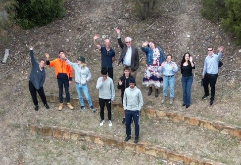
Supporting the pilot program were the Canberra Institute of Technology, TAFE NSW and some wonderful volunteers.
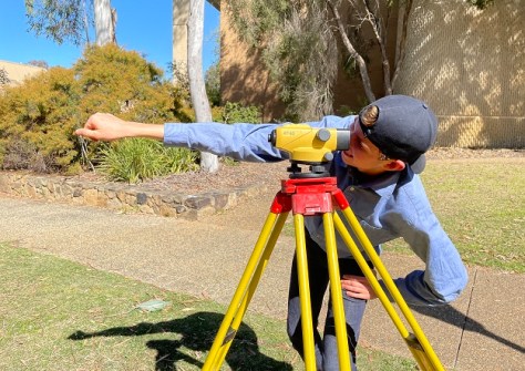
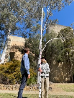
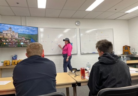
The Let’s Locate Surveying, Canberra 2024 immersion program was run from 30 September to 4 October and saw a small group of students from Canberra and as far away as Tamworth in northern NSW, spend an exciting week learning surveying skills and seeing drones and terrestrial laser scanning (TLS) in action. It was great to witness their enthusiasm, expertly encouraged by Libby Evans from TAFE NSW.
The students gained a basic awareness of levelling, traversing, detail surveys, set-out and the use of TLS and UAVs. On the last day they heard from and spoke with representatives of local surveying companies and education providers. Surveying Careers has been working on follow-up with the students.
The 2024 Canberra program was the first of a series of pilots intended to test and develop a framework for delivering Let’s Locate far beyond Canberra. Wherever there are students curious about our great surveying and geospatial industry, we need to be able to provide them with an opportunity to learn and progress.
It is anticipated the next Let’s Locate Surveying will be held in Sydney in early to mid-2025, with others to follow. On the Canberra front, work has begun on delivering Let’s Locate Geospatial in the first half of 2025. While the exact nature of the program is yet to be finalised, there has been some engagement with the local Planning Institute of Australia to jointly deliver a project-based planning program. Students will be able to bring together spatial data and information, perform site analysis and design a development. It will be a challenge for all — I can’t wait!!
I would like to thank all of the Let’s Locate partner organisations: Surveying Careers, Canberra Institute of Technology, TAFE NSW and GCA. Without them, Let’s Locate would not happen. Thanks also go to the wonderful local volunteers and local sponsors: Lonergan Surveying, Landmark Surveys, Veris Canberra, Spire Surveying and ACT Office of the Surveyor-General and Land Information.

Finally, to our teacher Libby Evans, from NSW TAFE in Albury NSW, a special thanks for bringing so much drive and enthusiasm. You really engaged the students. Despite rumours to the contrary, it had nothing to do with the handing out of Cadbury Favourites chocolates!
Some final thoughts. After our first Let’s Locate attempt in 2016, a Year 12 girl said, “All I thought I could do was hospitality. I never thought I could do something like this.” While we focus on getting more people into our industry to ‘get the job done,’ we should also remember that we can change a student’s future work trajectory and give them a truly rewarding career. We have so many exciting opportunities to change a student’s life.
Greg Ledwidge is the Surveyor-General of the Australian Capital Territory. For further information on the Let’s Locate program or to become involved, please email him at Greg.Ledwidge@act.gov.au.


