

Image courtesy Ertech
PARTNER CONTENT
When WA-based civil engineering company, Ertech, ran into problems during a dredging contract, they turned to a new solution supplied and installed by C.R. Kennedy.
The project in question was the construction of a new boating precinct for the town of Onslow, about 1,300 kilometres north of Perth. An existing boat ramp had become a bit rickety and would go underwater at high tide, so a new ramp was needed. The new facility will also have pens in which people can moor their boats, and from which diving tours and fishing charters can operate.
“For this project we had to dredge about 100,000 tonnes of dirt from the creek, and most of it was done underwater,” said Bradley Saunders, Ertech’s project manager and engineer for this job.
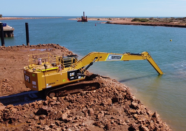
Ertech began by building a large, temporary bund, dewatered it and then — with a long-reach digger situated on top of the bund — began the process of removing lots of rock.
The rock they had to deal with was calcarenite, a type of limestone that has a very hard capstone but becomes a bit softer toward the bottom. Plus there was a lot of silty, clayey mud underneath and on top of the rock.
“Before we came up here, we had been told there was a 1.5-metre-thick rock shelf where we had to dredge. But once we started dredging, it turned out it was 3 metres thick, almost consistently across the whole thing,” said Saunders.
“A lot of the dredging was done by operators who couldn’t even see where the bucket was,” added Saunders. “So they might be pulling out material that’s six, seven metres below the tracks, and all they’ve got to go off is the screen and where it’s saying the bucket is.”
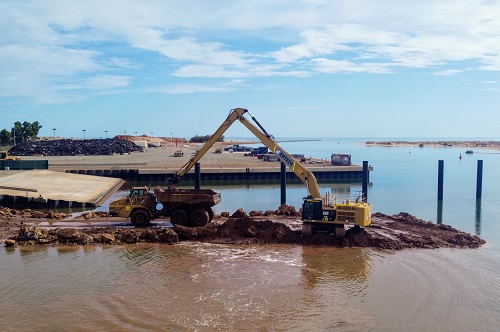
Image courtesy Ertech
At the beginning of the job, Ertech had been using legacy machine control equipment on its digger, but soon found that it was not up to the job. “We’d actually completed a significant part of the dredge when we brought in a subcontractor to do a hydrographic survey. It turned out that quite a significant amount of material was left high of the design levels.”
When Ertech investigated further, it turned out that the legacy machine control equipment was accurate to ±200 mm, sometimes ±300 mm. But with the job’s design tolerance being +0 mm and –300 mm, Ertech was taking it to the full tolerance and yet the result was still higher than designed.
In addition, Saunders said that when they used the legacy equipment underwater, it would go for a couple of weeks and then just stop working. “The saltwater and all the movement underwater just fried it,” he said.
“So I spoke to our survey manager, who spoke with C.R. Kennedy. They had this brand-new Leica Geosystems MC1 software on a MCP80 machine control system, along with the sensors and all the cabling that goes from the screen down the boom of the digger,” said Saunders. “It’s purpose-built for dredging, so all the sensors are waterproofed.”
C.R. Kennedy sent two technicians to the site and they installed the equipment in one day. The resulting accuracy improved to ±20mm.
“If you think of an excavator, it’s got a very long boom on it. Our digger is a super-long reach version, so it can boom horizontally out 21 metres,” said Saunders. “When you’re reaching that far, obviously all of the errors multiply significantly if you calibrate it incorrectly or if any of the sensors are off. So to get ±20 mm is exceptional.”
In addition, the legacy machine control equipment was so slow that the digger operators were experiencing a delay of around three seconds between moving the bucket and the control screen updating. That’s the sort of delay you would get if you were communicating with someone on the Moon. Clearly, it wasn’t good enough for a job where the bucket is underwater and the operator can’t see where it is.
“Imagine you’re trying to dig underwater, six metres below your tracks, and you can’t see what you’re doing. You move your bucket and then you have to wait. But this new Leica Geosystems system is almost instantaneous,” said Saunders. The improved performance “gave the operators more confidence with what they were doing, which is half the battle.”
“When we realised the legacy equipment wasn’t working as intended, the operators began to overcompensate, which led to more dredging than was necessary. But with this more accurate Leica Geosystems equipment, you can bring the tolerances back to what they should be, which saves time, effort, fuel and manpower.”
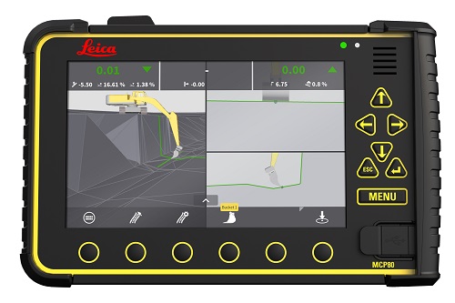
The Leica Geosystems MCP80
The MCP80 and MC1 combination’s features include:
- Fully cable free
- Easy removal of panel
- P67 environmental rating
- One common interface across all 3D machine control applications
- Simple and intuitive user interface
- Easy installation and quick setup for operators
- Rugged design of cradle and panel
- Docking station with onboard memory
“We’re actually switching out a lot of our legacy gear now and moving more towards Leica Geosystems,” said Saunders, adding that “C.R. Kennedy were great — they flew the guys up and they installed it in no time at all, and got the job running the way it should be done.”
This article was first published in the Oct/Nov 2022 issue of Position magazine.
Stay up to date by getting stories like this delivered to your inbox.
Sign up to receive our free weekly Spatial Source newsletter.


