

Australian property data platform company, Landchecker, has partnered with SAR and EO satellite company, ICEYE, to enhance its historical flood reporting.
The Landchecker platform is used by more than 160,000 property professionals. Founded in 2017, it is owned by the RACV and PEXA.
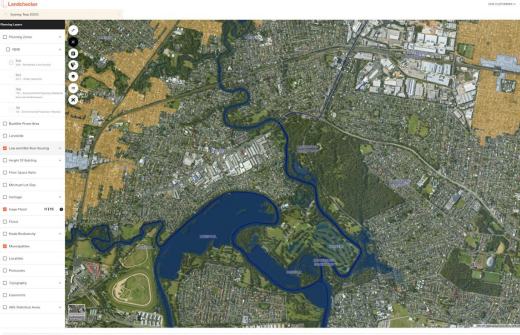
The platform’s map interface provides up-to-date views of land size, planning permits, development applications, zoning and overlays, and high-resolution aerial imagery, enabling the generation of insights and due diligence on any property in Australia.
ICEYE’s Flood Insights is an always-on data utility developed for the needs of the insurance sector. Powered by a constellation of cloud-penetrating satellites, it enables clients to accurately and quickly size damage, streamline claims processes, and build new products such as parametric offerings.
“ICEYE’s data is a game-changer for the Landchecker Platform,” said Adam Gandolfo, CEO of Landchecker.
“Access to accurate actual flood event data empowers our premium members to make informed decisions for their clients or for individuals to mitigate risk and ensure the long-term value of their properties.”

A derivative of ICEYE’s historical Flood Insights data across Australia will be available to premium tier users of Landchecker’s platform within the on-map functionality and reports of individual property locations, which conclude whether or not a flood had occurred and the estimated depth of the flood.
For an extra fee, standard users can unlock historical Flood Insights outlining the impact of flood events and the flood depth of the event on properties within Australia.
This can be paired with existing detail within Landchecker, including land size, frontage, orientation, school information, recent planning scheme amendments, proposed planning scheme amendments, aerial imagery, comparable sales, planning permit history, nearby planning permits, elevation, and digitised easements.
According to ICEYE, flooding is one of the biggest risks impacting Australian property today yet most due diligence still relies on static flood models.
“Landchecker’s premium customers have direct interests in historical flood information,” said Paul Barron, ICEYE’s Head of Global Partnerships.
“Developers, architects, and planners need ready access to accurate data that will inform decisions efficiently. Landchecker’s platform and reports provide an efficient way to search for site potential and feasibility which are enhanced by ICEYE’s Flood Insights.”


