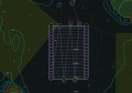
An elevation view of a platform laser scanned and 3D modelled by Intertek Surveying Services.
International company Intertek has announced the launch of Intertek Asset Integrity Management (AIM) Surveying Services in Australia.
Intertek Surveying Services (ISS) provides dimensional control, laser scanning and surveying services onshore and offshore to help customers meet engineering, construction and asset recording challenges. Intertek’s services are internationally deployed in many industries such as oil and gas, plant and process, shipbuilding, renewable energy, refining, petrochemical, nuclear, manufacturing, and aerospace.
With established hubs in Houston, USA, and the Highlands of Scotland, ISS is expanding physical presence in Australia to provide clients 3D laser scanning and dimensional control services.
Stuart Gordon, operations manager for ISS in Australia, has a decade of experience in laser scanning and surveying in the region. Based out of the existing Intertek office in Applecross, Western Australia, Stuart has quickly built a team to provide services for a long-term Australian LNG construction project and other high-profile projects in the region.
Kyle McNeil, Technical Operations Manager, at Intertek, said “We are very excited about the launch of our Intertek Surveying Services (ISS) business in these new regions. We foresee growth and increased demand for our specialised services, particularly from our clients involved in major LNG construction (modularisation projects), onshore and offshore platform and floaters construction.
“Surveying services have become an essential element in managing the entire life cycle of a project from design and construction through to installation, hook-up, commissioning, and additional upgrades and revamp. Customers in Australia and Brazil will now benefit from our in-depth knowledge and experience that will contribute to improving project execution schedules, site safety, increased accuracy, reduced field time and minimal rework with ISS.”