


Geoscience Australia’s Ginan GNSS analysis centre software has been upgraded to Version 2, with enhancements that provide users with real-time processing of observations from all the GNSS constellations without differencing or combining the data.
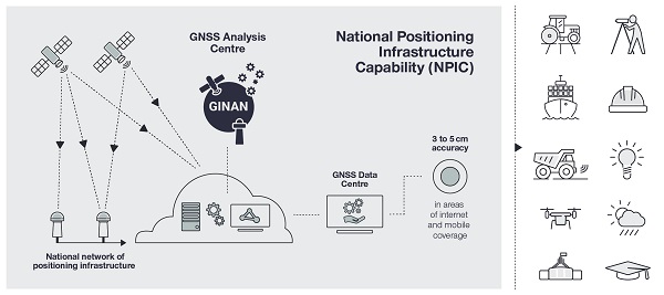
Ginan is a major part of Australia’s National Positioning Infrastructure Capability (NPIC), boosting positioning accuracy across the continent from 5 to 10 metres down to 3 to 5 centimetres.
“We are so proud of the impact that Ginan is making. By providing an open-source platform, Geoscience Australia is supporting GNSS education by allowing students and researchers to examine how the GNSS Analysis Centre Software algorithms work to solve complex problems,” said Anna Riddell, Director, GNSS Analysis.
“For example, we saw Ginan being used as the processing engine in the research conducted on the Tonga volcano eruption, which created a plasma bubble that deteriorated precise positioning”
According to Riddell, the interoperable nature of Ginan’s tools enables and encourages users to develop innovative GNSS position-dependent technology and services, which, in turn should spur growth for equipment manufacturers, technology integrators, service providers, the science community and end users.
“One of its key innovations is Ginan’s ability to process real-time data from different satellite systems while also estimating the sources of error that can degrade a position. This means it can quickly analyse signals from multiple satellite constellations, such as GPS, GLONASS, Galileo, and BeiDou, leading to faster and more accurate results,” said Riddell.
Ginan makes use of a processing method called UnCombined/UnDifferenced (UDUC), which improves accuracy by estimating certain errors. It can determine precise satellite orbits and handle data more effectively, removing unnecessary noise and errors for better analysis outcomes.
“The software provides robust data filtering capabilities, which means it can identify and remove anomalies like signal interruptions or outliers. This ensures that the processed data is of high quality and reliable,” said Riddell.
Ginan supports industry-standard messaging formats, enabling easy integration with other systems and devices. It also incorporates data from satellite laser ranging for enhanced orbit determination accuracy.
“The software has also undergone performance optimisations, resulting in faster analysis and improved operational stability,” added Riddell.
Detailed information about Ginan can be found on the Geoscience Australia website, while the software itself can be located at the Ginan GitHub repository.


