

Geospatial data, incorporated into a new app, is being used to help Māori reconnect with their whenua (land) and whakapapa (family tree).
The app, known as Kari, has been developed by New Zealand’s Te Herenga Waka – Victoria University of Wellington in collaboration with the Māori land incorporation, Parininihi ki Waitōtara (PKW).
The overall project, Kimihia te Matangaro, is part of the Science for Technological Innovation National Science Challenge.
According to Victoria University, “Kimihia te Matangaro is a project that empowers Māori communities to reconnect uri [descendants] with their whenua and whakapapa through automated linking of publicly accessible data”.
“Examples of impact include timely processing of successions, the reclamation of ancestral names for landblocks that catalyse new land use strategies, enhancing information access, and community engagement leading to more equitable decision-making.”
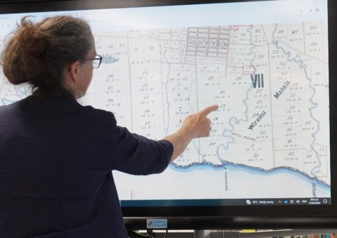
The app uses publicly available property data from Toitū Te Whenua Land Information New Zealand (LINZ), Māori Land Court, Births, Deaths and Marriages Historical Records and Cenotaph to identify specific names relating to whenua.
The aim of the project is to empower Māori to reconnect with long lost whanau (family), identify if they are a shareholder or landowner, process successions, and reconnect with their history.
It is hoped that through this process, Māori will experience increased economic, social, cultural prosperity and spiritual wellbeing.
LINZ Hoa Kōtui Hononga Matua / Senior Relationship Partner, Nicola Short, who has been involved throughout the project since its inception three years ago, said “I look forward to seeing the impact the app will have on Māori communities”.
Short says the project is a great example of how LINZ data can be used to create tools to reconnect people with their history and build a sense of belonging.


