Geoimage has joined DigitalGlobe for the launch of WorldView-4, the newest high-resolution, highly accurate commercial satellite to DigitalGlobe’s constellation.
WorldView-4 (also known as WV-4) will join DigitalGlobe’s existing constellation of images satellites WorldView 1, 2, 3, & 4, GeoEye-1 and QuickBird2. The satellite will be launched at the Vandenberg Air Force Base, California, within the coming days.
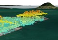
Now with the launch of WV-4, it will allow twice the amount of capture at 30cm Resolution, and therefore double the access to 50cm DEMs.”
As a DigitalGlobe partner and independent solutions provider, Brisbane-based Geoimage is supporting the launch in person and highly anticipating the new opportunities it will bring.
“We have seen 30cm data and 50cm digital elevation models (DEMS) to be a real game changer since the launch of WorldView-3 satellite,” said Sylvia Michael, Geospatial Processing & Technical Solutions Manager at Geoimage.
“Now with the launch of WV-4, it will allow twice the amount of capture at 30cm Resolution, and therefore double the access to 50cm DEMs (With WV-3 and WV-4).
“This means quicker captures, more coverage and unmatched quality in high resolution satellite data.”

The launch will be attended by Mark Edwards, Geoimage General Manager, and Director Tony Evans, who are among the privileged few from companies, dignitaries and government agencies around the globe invited to the launch.
Mr Edwards commented that the lunch is representative of their longstanding relationship: “Geoimage has a long history partnering with DigitalGlobe to access their high resolution imagery to assist our clients across Mining, Agricultural, Engineering, Environmental and other real world applications,” he said.
“Our Geospatial processing specialists are committed to translating our innovation and new spatial technologies into solutions that deliver greater efficiencies, lower costs and improved outcomes for clients.”