Image courtesy FrontierSI
FrontierSI has signed an agreement with Geoscience Australia, Curtin University and the University of Newcastle to collaborate on enhancing the Ginan system with features specifically aimed at supporting low-Earth orbit (LEO) satellites.
Ginan, Geoscience Australia’s GNSS analysis centre software, provides a real-time positioning correction service through open-source software, as well as additional positioning products to enable precise point positioning for Australian users.
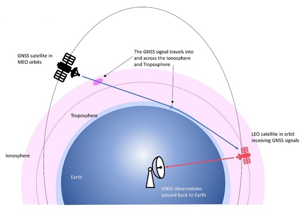
The agreement, which complements ongoing Ginan Precise Orbit Determination (POD) development activities, will focus on the implementation of LEO satellite modelling and the orbit integrator/propagator capabilities needed to enable LEO GNSS data to be processed and high-precision LEO satellite trajectories estimated and predicted.
This capability will enable:
- Better monitoring of LEO satellites for station keeping, collision avoidance and end-of-life purposes,
- Improved ionosphere and troposphere monitoring and modelling through the analysis of GNSS signal occultation, to provide data for weather prediction and precise positioning purposes.
“This is an exciting step forward as we continue to bring together the right skillsets, industry knowledge, and experience to develop ongoing initiatives and solutions for greater precise positioning,” said Graeme Kernich, FrontierSI’s CE.