

Biomass, the European Space Agency’s (ESA) forest measuring satellite is taking shape at Airbus’ site in Stevenage.
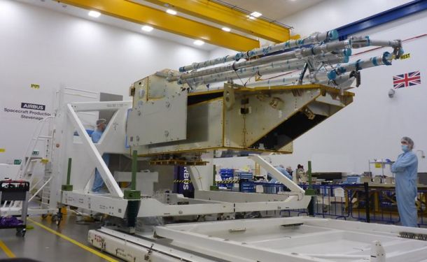
Biomass is taking shape at Airbus’ site in Stevenage, with the Structure Model Platform completed.
In line with UK Government guidelines, the Stevenage site is COVID-secure, enabling spacecraft production to continue safely. Assembly of the satellite’s mechanical structure could not be carried out as planned due to COVID. But during April and May 2020, the Airbus team put in place a digital application to enable collaboration with ESA and suppliers, ensuring progress continued on the development of the satellite’s mechanical structure.
Airbus teams finalised the structure building in the second half of 2020, and integration of the hardware onto the Structure Model Platform was completed in early January 2021. The Structure Model is now at Airbus Toulouse for its mechanical test campaign.
Managing director of Airbus Defence and Space UK Richard Franklin said: “Despite the pandemic the teams have really stepped up finding innovative ways to keep manufacturing on track. The progress made demonstrates the high level of skills and capabilities of the Airbus teams and their commitment to deliver on the project.”
ESA’s Biomass project manager Michael Fehringer said: “The status of the structure building as of today is a remarkable achievement given the number and variety of problems the teams had to face.”
Biomass is an ESA Earth Explorer mission due to launch in 2022. It will measure forest biomass to assess terrestrial carbon stocks and fluxes for five years. The spacecraft will carry the first space-borne P-band synthetic aperture radar to deliver exceptionally accurate maps of tropical, temperate and boreal forest biomass that are not obtainable by ground measurement techniques.
Stay up to date by getting stories like this delivered to your mailbox.
Sign up to receive our free weekly Spatial Source newsletter.


