

The first images have been released from Europe’s latest Copernicus program satellite, Sentinel-2C, and Planet Labs’ first Tanager-series hyperspectral satellite.
Sentinel-2C, the third in the Sentinel-2 series, was launched on 5 September from Europe’s Spaceport in French Guiana. Tanager-1 was launched on 16 August aboard SpaceX’s Transporter-11 multi-satellite mission.
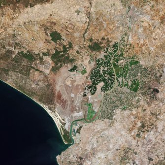
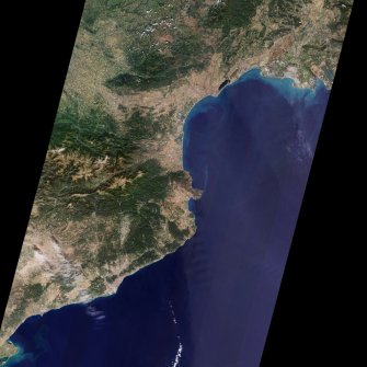
Sentinel-2C’s multispectral imager has a swath width of 290 km and provides continuous imagery in 13 spectral bands at resolutions of 10 m, 20 m and 60 m from an orbital altitude of 786 kilometres.
Some of its first images show Seville in southern Spain, a strip of coastline from Montpellier in southern France to south of Barcelona in Spain, and Lighthouse Reef off the coast of Belize.
Sentinel-2C’s imager is still being calibrated as part of the satellite’s commissioning phase, a process that will take three months.

“It is truly remarkable how well the multispectral instrument had been calibrated even before the satellite was launched, producing such stunning first images,” said Francisco Reina, Sentinel-2 Payload Manager.
“This achievement is the result of an outstanding collaboration between ESA and the Airbus teams throughout the instrument’s development phase.”
Once commissioning is complete, Sentinel-2C will take over operations from Sentinel-2A, which has been in orbit since June 2015.
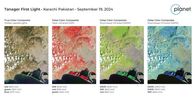
The first publicly released images from Planet Labs’ Tanager-1 hyperspectral satellite show Karachi in Pakistan. The data was collected on 19 September from an altitude of 522 kilometres.
Tanager-1 is the first of a planned constellation of hyperspectral satellites, all based on Planet Labs’ Smallsat platform and featuring a state-of-the-art imaging spectrometer design developed at NASA’s Jet Propulsion Laboratory.
Tanager-1 is capable of imaging all wavelengths between 400 and 2500 nm simultaneously, with the data to be used to produce data cubes with 420 spectral channels.
The imagery below shows standard RGB, false-colour near-IR and false-colour shortwave IR, using only six of the available bands.
“Tanager first light is the biggest program milestone yet,” said Mark Keremedjiev, Planet Labs’ Mission Director for the Tanager Hyperspectral Mission.
“It’s early days but we are very pleased with the quality we are seeing, and we believe that first light is but a preview of amazing things to come.”


