State survey mark spotting is an activity that is educational and fun, promotes community engagement and delivers real-world benefits to the profession.
By Volker Janssen
Surveying is plagued by a notorious skills shortage and continuing problems of attracting enough tertiary students to feed demand. The ageing demographic of the existing workforce and a lack of diversity within the profession only exacerbate these woes.
Promotion of the profession to school aged students reaches a wide audience and helps develop a pipeline of future surveyors. This article reports on an initiative to engage primary school students (and their parents) with surveying in a way that is educational, healthy and fun, while also promoting community engagement and delivering real-world benefits to the surveying profession.
DCS Spatial Services, a unit of the NSW Department of Customer Service (DCS), is responsible for the maintenance and improvement of the NSW survey control network, made available to users via the Survey Control Information Management System (SCIMS). SCIMS is the state’s database containing more than 250,000 survey marks on public record, including State Survey Marks (SSMs) and Permanent Marks (PMs).
SSM spotting
Bathurst South Public School is a primary school educating about 220 students from kindergarten through to Year 6. After conceiving and testing an idea during the COVID-19 pandemic lockdown, the author approached the school with a proposal to introduce ‘SSM spotting’ as an activity that ticks the boxes of education, exercise and mental health, but also promotes community engagement.
The aim was to engage students (and their parents or carers) with surveying and encourage them to view their surroundings a little differently (as most people are oblivious to survey marks), while producing rewarding outcomes used by the NSW Government and the surveying profession.
Students would be asked to take their parents/carers for a walk, find SSMs located along the kerb, investigate the mark’s health, take photographs, organise the images, and then upload the data to the school. DCS Spatial Services would add these images to its archive of survey mark photos and update SCIMS with associated metadata.

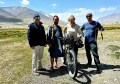
The proposal was met with considerable support and enthusiasm, and it was decided to trial the activity with a single Year 5/6 class in 2022. After completing the mandatory Working with Children Check, the author gave a presentation to introduce the activity, followed by a practical demonstration at two survey marks in front of the school.
Soon after, a class excursion was organised where students would take turns in finding, checking and photographing survey marks while walking along residential streets surrounding the school. The excursion was well received by the students who were eager to participate in this peculiar treasure hunt.
During this time, relevant documentation and processes were refined based on the experience gained and any feedback received. This included considering the following concerns:
- Road safety: Students and their parents/carers will be used to walking on the footpaths along their local roads, so this should not be an issue. If their residence is along a busy road, they should select a quieter area instead.
- Wheelchair access: Footpaths suitable for wheelchairs are available in various parts of town, providing safe access to survey marks.
- Children in photos: Parents/carers need to be made aware that the photos taken of the survey marks will be included in the NSW Government’s archive of survey mark photos. Having their children shown in the photos is optional and not necessarily encouraged.
- Privacy: The names of participating students are not disclosed to DCS Spatial Services. Any file or folder names including personal information are anonymised before being passed on.
- Work Health and Safety (WHS): The activity was assessed and conducted under the school’s WHS policies and insurances.
Due to the packed curriculum and other school activities taking priority, it took another year until SSM spotting was rolled out across all stage 3 (Years 5 and 6) classes in 2023. Again, this was accompanied by a presentation and practical demonstration. The activity was also promoted in two issues of the weekly newsletter distributed to students and their families.
Instructions for students
Background information and instructions provided in written form and during the presentation and demonstration sessions purposely used language appropriate to the target audience.
It was explained that surveyors are experts at knowing their location or position. They measure angles, distances, height differences and positions to determine where things are and how they relate to each other. Students were introduced to different types of survey marks (and their purpose) and informed that the data collected will be used by the NSW Government for the benefit of the community.
In summary, the instructions included:
- Take a parent/carer for a walk in the neighbourhood and find at least three SSMs located along the kerb of the road.
- Inspect the survey mark, brush off dust if required, and write its number and health status (stable, unstable or damaged) on a notepad.
- Take up to five photos in landscape format, including a close-up of the mark itself showing its number plate and (if possible and safe to do so) a photo from each of four perpendicular directions showing the mark and its background.
- Move clockwise around the mark when taking photos and place a colourful water bottle next to the mark, so it can easily be identified in the photos.
- Take a photo of the simple list showing the marks spotted and their health status.
- Download the photos and rename them, so we can easily see which photo belongs to which survey mark and when it was taken (e.g. SS123456_20230402_1.jpg and SSM_health.jpg).
- Organise the files into folders and upload them to the school.
- How to use the free NSW Survey Marks smartphone app to explore survey marks further or get some clues about where to find them.
- How to use the sketch plan like a treasure map to find the survey mark.
- What to bring and how to be safe.
The uploaded files were checked (and anonymised if required) by the school and passed on to DCS Spatial Services. Data management then included ensuring correct file naming, selecting the preferred set of photographs for marks spotted by multiple students and assessing the health status of each mark. A tally was kept, documenting the marks spotted and including metadata required for the SCIMS update.
Results
The SSM spotting activity at Bathurst South Public School resulted in 275 survey marks (including 25 PMs) being spotted, photographed and then updated in SCIMS. The photos have been added to the DCS Spatial Services archive, significantly increasing the number of survey marks with available images in Bathurst.
In the future, these photos may be made available to surveyors via a modernised SCIMS to assist in survey planning, e.g. in determining whether a particular mark is affected by tree cover or other obstructions or whether an instrument can be set up safely and with minimal disruption to traffic. Blur filters may then be applied to protect the privacy of any persons in the photos if required.


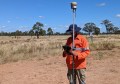
The SCIMS metadata update included specifying the mark status (generally ‘found intact’) with a corresponding comment and date, along with specifying (or confirming) the mark type and information about who placed the mark (and when it was placed) by interrogating the locality sketch plan. For PMs, the height of the mark below/above ground level was also measured and archived (for SSMs this value was generally zero).
Some survey marks were found damaged or in need of repair. The students’ notes and the close-up photos were crucial in ascertaining whether repair work was required.
DCS Spatial Services performed repairs where the SSM brass plaque was wobbling in the concrete, removable from the kerb, buried by recently added bitumen or where part of the mark number had been rubbed out. Some PMs were repaired to allow easy opening and closing of the cover box, and to remove trip hazards caused by stuck or missing lids. On one occasion, a cover box that had been pushed off the mark (thereby preventing it from being occupied) was recentred, enabling it to return to service.
Challenges
While these results are very pleasing and encouraging, several challenges were encountered. Despite the considerable support and enthusiasm shown by the school, it proved difficult to include SSM spotting in an already packed curriculum. This caused it to be drawn out over two school years, which may have negatively affected the enthusiasm shown by the students involved in the initial pilot.
Like homework, the activity was not compulsory (or not promoted as such). Unfortunately, it was not possible to include SSM spotting as an option in the suggested homework roster distributed to students for the school term. The activity relied on parental supervision, and parents/carers might have been more inclined to partake or adequately prepare for the activity if it had been perceived as compulsory.
While there was a lot of interest among students, particularly during the very successful class excursion, only a few students followed through with the entire activity in their own time. Several students reported spotting survey marks but not taking any photos at the time or taking some photos but not uploading them to the school. The offer to help with the downloading and renaming of images in the school’s computer lab was not taken up.

Consequently, most marks were completed by only a few students, mainly by the author’s daughter (who, understandably, became less enthusiastic as time went on). Asking a few school friends to come along increased the fun factor and extended the duration of the activity. Towards the end, the author embarked on a couple of solo trips to capture the remaining survey marks in a particular area.
The SSM spotting activity attracted the attention of concerned residents on social media. A local neighbourhood group lit up with posts pertaining to a strange person walking the streets, apparently taking photos of his water bottle sitting on the gutter, sometimes with children posing in the photos.
While some posts were concerned about the person’s mental wellbeing, others speculated that he may have a more sinister motive, actually taking photos of people’s houses to determine whether CCTV cameras are installed. The mystery was eventually solved via an explanatory post by one of the author’s colleagues. A few residents made the effort to say hello to the strange person and were promptly informed of the school activity taking place.
Potential future extensions
SSM spotting can easily be adapted to students at high school, vocational education and training (VET) institutions and university. High school students may be more suited than primary school kids as they are more independent and potentially more eager to follow through depending on their possible job interests.
As a potential extra relating to spatial awareness, younger students could be asked to draw a treasure map of the roads searched, indicating with a symbol where each SSM was found, labelling them accordingly and including a north arrow. For older kids, the activity could be modified by first checking SCIMS (via the free NSW Survey Marks app) for suitable marks to track down, similar to geocaching.
In urban areas, it could be expanded to include PMs in the footpath, provided the appropriate tools are carried and WHS measures are in place (e.g. including a large screwdriver to open the cover box, a glove for protection from animals and to scoop out dirt, and a measuring tape to determine the mark-to-ground-level height).
From high-school age onwards, students could be asked to measure coordinates with a smartphone or handheld GNSS unit and create a map with an open-source GIS package. This progression from treasure hunt to taking simple measurements would not only increase the activity’s challenge and complexity but would also enable an introduction to coordinate types and systems.
Students starting a VET or university course in surveying could benefit from SSM spotting as an activity to get a better understanding of the different types of survey marks and their importance, along with exposure to the NSW Survey Marks app, SCIMS and the role of state government in maintaining the state’s survey infrastructure.
Searching for, identifying and photographing survey marks and updating their metadata could be a useful hands-on practical field exercise. Students could be required to identify a variety of survey marks (cadastral and survey control), including examples of ‘found,’ ‘uncertain’ and ‘destroyed’ marks, and use the app to submit updated metadata. In addition, they could load these as a layer in a GIS and be required to find marks not previously visited by other students.
The wider profession could also be involved in SSM spotting, e.g. while contributing to a worthy cause. STEPtember is a global health and wellness fundraising event supporting life-changing cerebral palsy research. It encourages participants of all fitness and ability levels to take part in more than 40 activities to complete a daily target of 10,000 steps. The profession is encouraged to mimic the primary school students and find as many survey marks as possible, while staying healthy and supporting a worthy cause.
The NSW Survey Marks app has the potential of being an important tool to help engage students and potentially foster citizen science if it is desired to target an even wider audience (such as the geocaching community). Via its report function, the app can be used by any person to easily upload photos and report on the health status of a survey mark. However, it should be noted that this provides a direct conduit to DCS Spatial Services rather than utilising a moderator as may be desired for a school or tertiary education project to avoid duplication.
It is hoped that SSM spotting will help to educate the general public about what surveyors do, raise the profession’s public profile and eventually result in more people choosing a career as a surveyor or geospatial professional.
Dr Volker Janssen works at DCS Spatial Services, a unit of the NSW Department of Customer Service.